You are here: Home > Network List > TA - USArray Transportable Network (new EarthScope stations) Stations List
> Station Y32A R-V Farms, Vernon, TX, USA > Earthquake Result Viewer
Y32A R-V Farms, Vernon, TX, USA - Earthquake Result Viewer
| Earthquake location: |
Fox Islands, Aleutian Islands |
| Earthquake latitude/longitude: |
52.8/-169.7 |
| Earthquake time(UTC): |
2010/07/18 (199) 19:48:04 GMT |
| Earthquake Depth: |
10 km |
| Earthquake Magnitude: |
5.6 MB, 5.6 MS, 6.0 MW, 6.0 MW |
| Earthquake Catalog/Contributor: |
WHDF/NEIC |
|
| Network: |
TA USArray Transportable Network (new EarthScope stations) |
| Station: |
Y32A R-V Farms, Vernon, TX, USA |
| Lat/Lon: |
34.00 N/99.44 W |
| Elevation: |
412 m |
|
| Distance: |
52.2 deg |
| Az: |
81.629 deg |
| Baz: |
313.71 deg |
| Ray Param: |
0.066895634 |
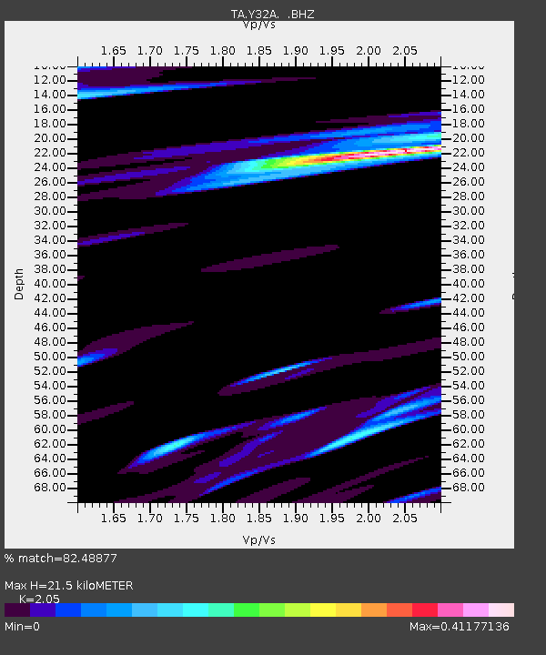
| Estimated Moho Depth: |
21.5 km |
| Estimated Crust Vp/Vs: |
2.05 |
| Assumed Crust Vp: |
6.315 km/s |
| Estimated Crust Vs: |
3.081 km/s |
| Estimated Crust Poisson's Ratio: |
0.34 |
|
| Radial Match: |
82.48877 % |
| Radial Bump: |
400 |
| Transverse Match: |
64.31128 % |
| Transverse Bump: |
400 |
| SOD ConfigId: |
319893 |
| Insert Time: |
2011-01-05 07:23:47.323 +0000 |
| GWidth: |
2.5 |
| Max Bumps: |
400 |
| Tol: |
0.001 |
|
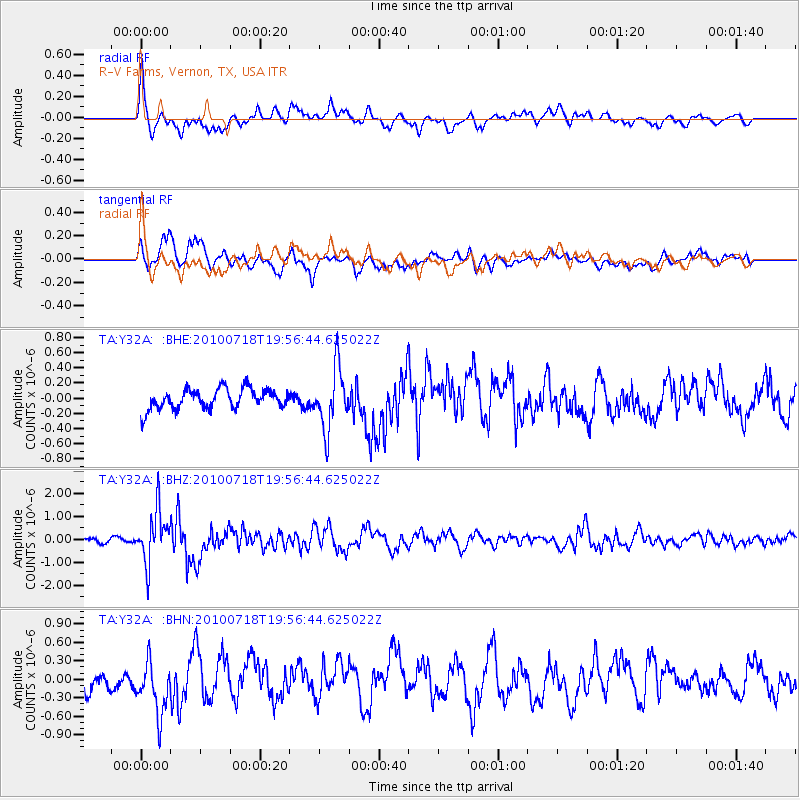
Signal To Noise
| Channel | StoN | STA | LTA |
| TA:Y32A: :BHZ:20100718T19:56:44.625022Z | 14.516379 | 1.1158652E-6 | 7.686939E-8 |
| TA:Y32A: :BHN:20100718T19:56:44.625022Z | 3.178218 | 4.4086198E-7 | 1.3871357E-7 |
| TA:Y32A: :BHE:20100718T19:56:44.625022Z | 2.955448 | 3.9156936E-7 | 1.324907E-7 |
| Arrivals |
| Ps | 3.7 SECOND |
| PpPs | 9.9 SECOND |
| PsPs/PpSs | 14 SECOND |


