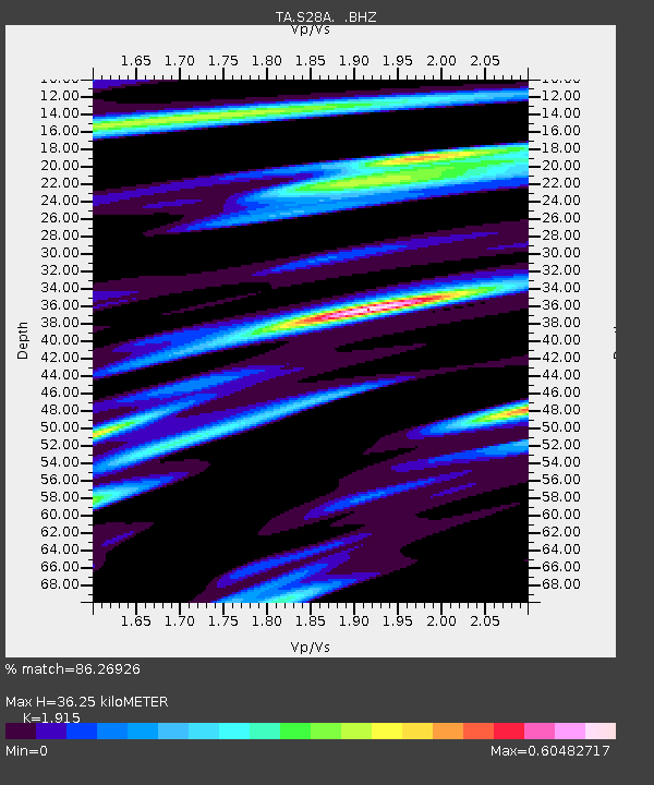
S28A Manter, KS, USA - Earthquake Result Viewer

Earthquake location: Fox Islands, Aleutian Islands
Earthquake latitude/longitude: 52.8/-169.7
Earthquake time(UTC): 2010/07/18 (199) 19:48:04 GMT
Earthquake Depth: 10 km
Earthquake Magnitude: 5.6 MB, 5.6 MS, 6.0 MW, 6.0 MW
Earthquake Catalog/Contributor: WHDF/NEIC
Network: TA USArray Transportable Network (new EarthScope stations)
Station: S28A Manter, KS, USA
Lat/Lon: 37.59 N/101.90 W
Elevation: 1064 m
Distance: 48.3 deg
Az: 79.95 deg
Baz: 311.205 deg
Ray Param: 0.06942692
Estimated Moho Depth: 36.25 km
Estimated Crust Vp/Vs: 1.91
Assumed Crust Vp: 6.483 km/s
Estimated Crust Vs: 3.385 km/s
Estimated Crust Poisson's Ratio: 0.31
Radial Match: 86.26926 %
Radial Bump: 399
Transverse Match: 52.563747 %
Transverse Bump: 400
SOD ConfigId: 319893
Insert Time: 2011-01-05 07:24:41.986 +0000
GWidth: 2.5
Max Bumps: 400
Tol: 0.001

Signal To Noise

ChannelStoNSTALTA
TA:S28A: :BHZ:20100718T19:56:15.200004Z16.4860611.2011958E-67.28613E-8
TA:S28A: :BHN:20100718T19:56:15.200004Z2.27223.858328E-71.6980583E-7
TA:S28A: :BHE:20100718T19:56:15.200004Z4.3068345.394525E-71.2525501E-7
Arrivals
Ps5.4 SECOND
PpPs15 SECOND
PsPs/PpSs21 SECOND