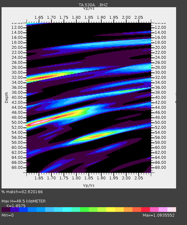
S30A Montezuma, KS, USA - Earthquake Result Viewer
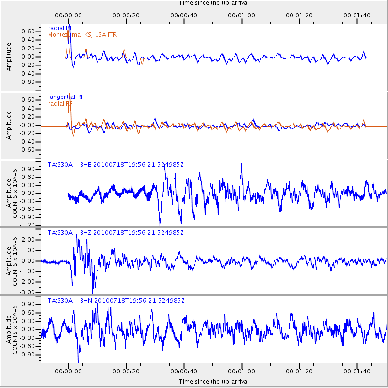
Earthquake location: Fox Islands, Aleutian Islands
Earthquake latitude/longitude: 52.8/-169.7
Earthquake time(UTC): 2010/07/18 (199) 19:48:04 GMT
Earthquake Depth: 10 km
Earthquake Magnitude: 5.6 MB, 5.6 MS, 6.0 MW, 6.0 MW
Earthquake Catalog/Contributor: WHDF/NEIC
Network: TA USArray Transportable Network (new EarthScope stations)
Station: S30A Montezuma, KS, USA
Lat/Lon: 37.64 N/100.46 W
Elevation: 853 m
Distance: 49.2 deg
Az: 78.9 deg
Baz: 311.384 deg
Ray Param: 0.068880185
Estimated Moho Depth: 49.5 km
Estimated Crust Vp/Vs: 1.66
Assumed Crust Vp: 6.483 km/s
Estimated Crust Vs: 3.911 km/s
Estimated Crust Poisson's Ratio: 0.21
Radial Match: 82.920166 %
Radial Bump: 400
Transverse Match: 53.631657 %
Transverse Bump: 400
SOD ConfigId: 319893
Insert Time: 2011-01-05 07:25:01.061 +0000
GWidth: 2.5
Max Bumps: 400
Tol: 0.001

Signal To Noise

ChannelStoNSTALTA
TA:S30A: :BHZ:20100718T19:56:21.524985Z11.4161351.1683277E-61.0234003E-7
TA:S30A: :BHN:20100718T19:56:21.524985Z3.09424834.632694E-71.4971954E-7
TA:S30A: :BHE:20100718T19:56:21.524985Z3.62225875.282172E-71.4582537E-7
Arrivals
Ps5.4 SECOND
PpPs19 SECOND
PsPs/PpSs24 SECOND