You are here: Home > Network List > US - United States National Seismic Network Stations List
> Station HAWA Hanford, Washington, USA > Earthquake Result Viewer
HAWA Hanford, Washington, USA - Earthquake Result Viewer
*The percent match for this event was below the threshold and hence no stack was calculated.
| Earthquake location: |
Central East Pacific Rise |
| Earthquake latitude/longitude: |
-4.7/-105.9 |
| Earthquake time(UTC): |
2023/09/20 (263) 15:03:36 GMT |
| Earthquake Depth: |
10 km |
| Earthquake Magnitude: |
5.7 mww |
| Earthquake Catalog/Contributor: |
NEIC PDE/us |
|
| Network: |
US United States National Seismic Network |
| Station: |
HAWA Hanford, Washington, USA |
| Lat/Lon: |
46.39 N/119.53 W |
| Elevation: |
364 m |
|
| Distance: |
52.3 deg |
| Az: |
348.108 deg |
| Baz: |
162.738 deg |
| Ray Param: |
$rayparam |
*The percent match for this event was below the threshold and hence was not used in the summary stack. |
|
| Radial Match: |
85.41456 % |
| Radial Bump: |
219 |
| Transverse Match: |
19.178226 % |
| Transverse Bump: |
255 |
| SOD ConfigId: |
31937991 |
| Insert Time: |
2023-10-04 15:39:47.886 +0000 |
| GWidth: |
2.5 |
| Max Bumps: |
400 |
| Tol: |
0.001 |
|
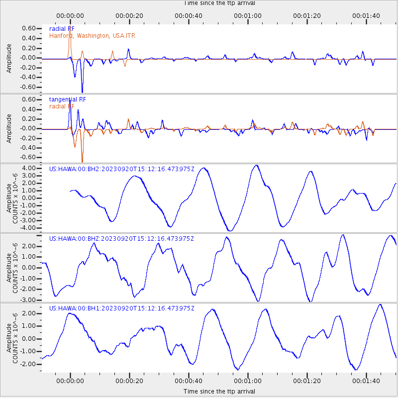
Signal To Noise
| Channel | StoN | STA | LTA |
| US:HAWA:00:BHZ:20230920T15:12:16.473975Z | 0.8740618 | 1.1776872E-6 | 1.3473729E-6 |
| US:HAWA:00:BH1:20230920T15:12:16.473975Z | 1.5506598 | 1.8851433E-6 | 1.215704E-6 |
| US:HAWA:00:BH2:20230920T15:12:16.473975Z | 1.6217259 | 2.8935258E-6 | 1.7842261E-6 |
| Arrivals |
| Ps | |
| PpPs | |
| PsPs/PpSs | |


