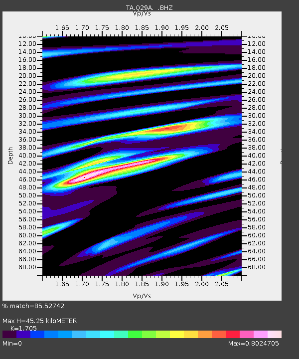
Q29A Oakley, KS, USA - Earthquake Result Viewer

Earthquake location: Fox Islands, Aleutian Islands
Earthquake latitude/longitude: 52.8/-169.7
Earthquake time(UTC): 2010/07/18 (199) 19:48:04 GMT
Earthquake Depth: 10 km
Earthquake Magnitude: 5.6 MB, 5.6 MS, 6.0 MW, 6.0 MW
Earthquake Catalog/Contributor: WHDF/NEIC
Network: TA USArray Transportable Network (new EarthScope stations)
Station: Q29A Oakley, KS, USA
Lat/Lon: 38.89 N/100.98 W
Elevation: 895 m
Distance: 48.0 deg
Az: 77.996 deg
Baz: 310.469 deg
Ray Param: 0.06961447
Estimated Moho Depth: 45.25 km
Estimated Crust Vp/Vs: 1.71
Assumed Crust Vp: 6.483 km/s
Estimated Crust Vs: 3.802 km/s
Estimated Crust Poisson's Ratio: 0.24
Radial Match: 85.52742 %
Radial Bump: 400
Transverse Match: 67.032455 %
Transverse Bump: 400
SOD ConfigId: 319893
Insert Time: 2011-01-05 07:25:52.483 +0000
GWidth: 2.5
Max Bumps: 400
Tol: 0.001

Signal To Noise

ChannelStoNSTALTA
TA:Q29A: :BHZ:20100718T19:56:12.874991Z9.2432348.974447E-79.709208E-8
TA:Q29A: :BHN:20100718T19:56:12.874991Z4.56187964.786348E-71.0492051E-7
TA:Q29A: :BHE:20100718T19:56:12.874991Z4.5170044.855674E-71.0749766E-7
Arrivals
Ps5.2 SECOND
PpPs18 SECOND
PsPs/PpSs23 SECOND