You are here: Home > Network List > UW - Pacific Northwest Regional Seismic Network Stations List
> Station HOOD Mt Hood Meadows, OR CREST BB SMO > Earthquake Result Viewer
HOOD Mt Hood Meadows, OR CREST BB SMO - Earthquake Result Viewer
*The percent match for this event was below the threshold and hence no stack was calculated.
| Earthquake location: |
Central East Pacific Rise |
| Earthquake latitude/longitude: |
-4.7/-105.9 |
| Earthquake time(UTC): |
2023/09/20 (263) 15:03:36 GMT |
| Earthquake Depth: |
10 km |
| Earthquake Magnitude: |
5.7 mww |
| Earthquake Catalog/Contributor: |
NEIC PDE/us |
|
| Network: |
UW Pacific Northwest Regional Seismic Network |
| Station: |
HOOD Mt Hood Meadows, OR CREST BB SMO |
| Lat/Lon: |
45.32 N/121.65 W |
| Elevation: |
1520 m |
|
| Distance: |
51.7 deg |
| Az: |
345.891 deg |
| Baz: |
159.855 deg |
| Ray Param: |
$rayparam |
*The percent match for this event was below the threshold and hence was not used in the summary stack. |
|
| Radial Match: |
97.3735 % |
| Radial Bump: |
338 |
| Transverse Match: |
59.58777 % |
| Transverse Bump: |
400 |
| SOD ConfigId: |
31937991 |
| Insert Time: |
2023-10-04 15:41:21.271 +0000 |
| GWidth: |
2.5 |
| Max Bumps: |
400 |
| Tol: |
0.001 |
|
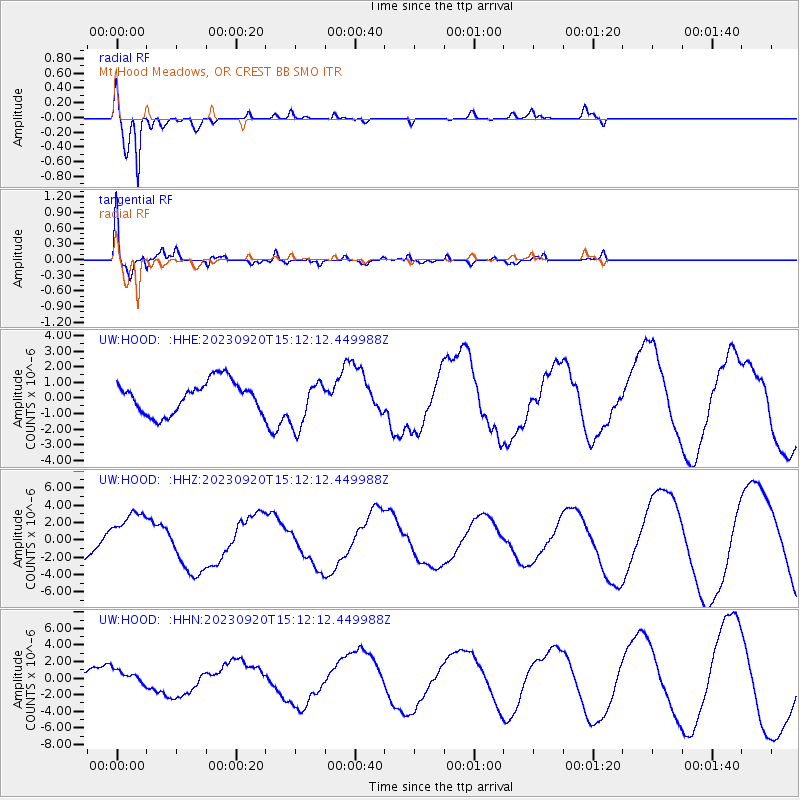
Signal To Noise
| Channel | StoN | STA | LTA |
| UW:HOOD: :HHZ:20230920T15:12:12.449988Z | 2.1611238 | 2.9508076E-6 | 1.3654043E-6 |
| UW:HOOD: :HHN:20230920T15:12:12.449988Z | 0.8940186 | 9.459495E-7 | 1.0580872E-6 |
| UW:HOOD: :HHE:20230920T15:12:12.449988Z | 1.5036683 | 1.5288527E-6 | 1.0167486E-6 |
| Arrivals |
| Ps | |
| PpPs | |
| PsPs/PpSs | |


