You are here: Home > Network List > WW - Idaho Seismic Network () Stations List
> Station BILL Emerald Creek, Idaho > Earthquake Result Viewer
BILL Emerald Creek, Idaho - Earthquake Result Viewer
| Earthquake location: |
Central East Pacific Rise |
| Earthquake latitude/longitude: |
-4.7/-105.9 |
| Earthquake time(UTC): |
2023/09/20 (263) 15:03:36 GMT |
| Earthquake Depth: |
10 km |
| Earthquake Magnitude: |
5.7 mww |
| Earthquake Catalog/Contributor: |
NEIC PDE/us |
|
| Network: |
WW Idaho Seismic Network () |
| Station: |
BILL Emerald Creek, Idaho |
| Lat/Lon: |
47.03 N/116.34 W |
| Elevation: |
866 m |
|
| Distance: |
52.3 deg |
| Az: |
351.003 deg |
| Baz: |
166.828 deg |
| Ray Param: |
0.06684365 |
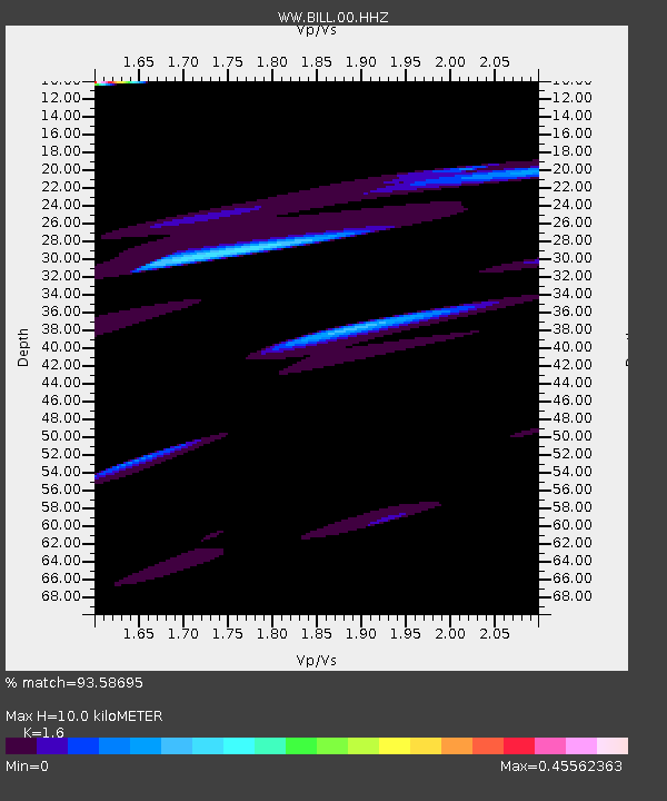
| Estimated Moho Depth: |
10.0 km |
| Estimated Crust Vp/Vs: |
1.60 |
| Assumed Crust Vp: |
6.571 km/s |
| Estimated Crust Vs: |
4.107 km/s |
| Estimated Crust Poisson's Ratio: |
0.18 |
|
| Radial Match: |
93.58695 % |
| Radial Bump: |
400 |
| Transverse Match: |
63.83945 % |
| Transverse Bump: |
400 |
| SOD ConfigId: |
31937991 |
| Insert Time: |
2023-10-04 15:43:39.743 +0000 |
| GWidth: |
2.5 |
| Max Bumps: |
400 |
| Tol: |
0.001 |
|
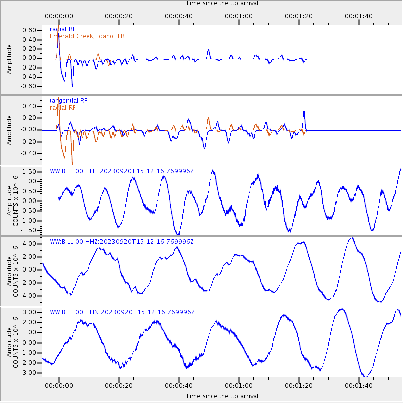
Signal To Noise
| Channel | StoN | STA | LTA |
| WW:BILL:00:HHZ:20230920T15:12:16.769996Z | 1.9324019 | 3.0300205E-6 | 1.5680074E-6 |
| WW:BILL:00:HHN:20230920T15:12:16.769996Z | 0.7108908 | 8.1730514E-7 | 1.1496915E-6 |
| WW:BILL:00:HHE:20230920T15:12:16.769996Z | 0.9093555 | 6.123172E-7 | 6.7335293E-7 |
| Arrivals |
| Ps | 1.0 SECOND |
| PpPs | 3.7 SECOND |
| PsPs/PpSs | 4.7 SECOND |


