You are here: Home > Network List > IW - Intermountain West Stations List
> Station MOOW Moose Ponds, Wyoming, USA > Earthquake Result Viewer
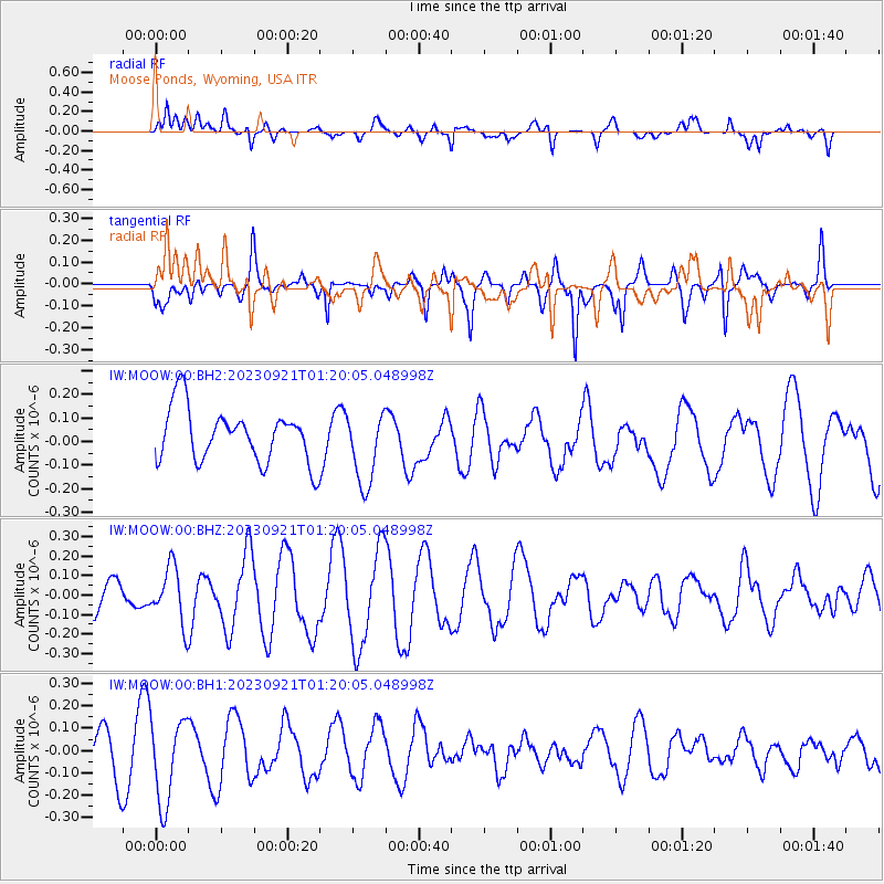
MOOW Moose Ponds, Wyoming, USA - Earthquake Result Viewer
*The percent match for this event was below the threshold and hence no stack was calculated.
| Earthquake location: |
Alaska Peninsula |
| Earthquake latitude/longitude: |
54.9/-160.3 |
| Earthquake time(UTC): |
2023/09/21 (264) 01:13:58 GMT |
| Earthquake Depth: |
24 km |
| Earthquake Magnitude: |
5.5 ml |
| Earthquake Catalog/Contributor: |
NEIC PDE/ak |
|
| Network: |
IW Intermountain West |
| Station: |
MOOW Moose Ponds, Wyoming, USA |
| Lat/Lon: |
43.75 N/110.74 W |
| Elevation: |
2128 m |
|
| Distance: |
33.5 deg |
| Az: |
88.483 deg |
| Baz: |
307.161 deg |
| Ray Param: |
$rayparam |
*The percent match for this event was below the threshold and hence was not used in the summary stack. |
|
| Radial Match: |
61.220116 % |
| Radial Bump: |
400 |
| Transverse Match: |
46.003323 % |
| Transverse Bump: |
286 |
| SOD ConfigId: |
31937991 |
| Insert Time: |
2023-10-05 01:23:28.560 +0000 |
| GWidth: |
2.5 |
| Max Bumps: |
400 |
| Tol: |
0.001 |
|
Signal To Noise
| Channel | StoN | STA | LTA |
| IW:MOOW:00:BHZ:20230921T01:20:05.048998Z | 1.2376616 | 1.437386E-7 | 1.16137244E-7 |
| IW:MOOW:00:BH1:20230921T01:20:05.048998Z | 1.2847588 | 1.8870294E-7 | 1.4687811E-7 |
| IW:MOOW:00:BH2:20230921T01:20:05.048998Z | 1.3936223 | 1.5751576E-7 | 1.13026154E-7 |
| Arrivals |
| Ps | |
| PpPs | |
| PsPs/PpSs | |


