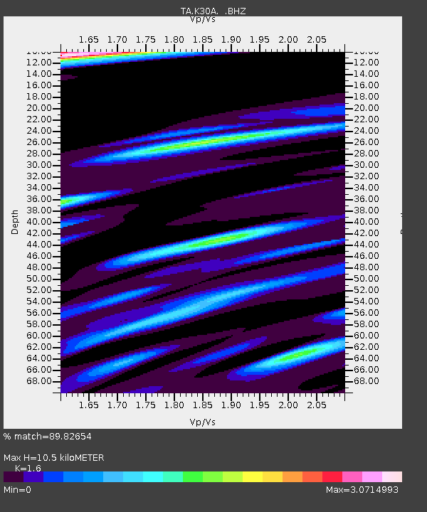
K30A Basset, NE, USA - Earthquake Result Viewer
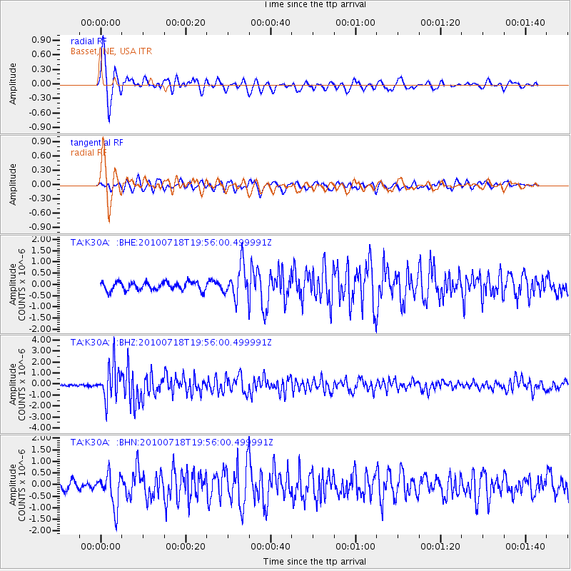
Earthquake location: Fox Islands, Aleutian Islands
Earthquake latitude/longitude: 52.8/-169.7
Earthquake time(UTC): 2010/07/18 (199) 19:48:04 GMT
Earthquake Depth: 10 km
Earthquake Magnitude: 5.6 MB, 5.6 MS, 6.0 MW, 6.0 MW
Earthquake Catalog/Contributor: WHDF/NEIC
Network: TA USArray Transportable Network (new EarthScope stations)
Station: K30A Basset, NE, USA
Lat/Lon: 42.67 N/99.61 W
Elevation: 712 m
Distance: 46.4 deg
Az: 73.116 deg
Baz: 308.043 deg
Ray Param: 0.07063991
Estimated Moho Depth: 10.5 km
Estimated Crust Vp/Vs: 1.60
Assumed Crust Vp: 6.53 km/s
Estimated Crust Vs: 4.082 km/s
Estimated Crust Poisson's Ratio: 0.18
Radial Match: 89.82654 %
Radial Bump: 400
Transverse Match: 77.17836 %
Transverse Bump: 400
SOD ConfigId: 319893
Insert Time: 2011-01-05 07:31:58.157 +0000
GWidth: 2.5
Max Bumps: 400
Tol: 0.001

Signal To Noise

ChannelStoNSTALTA
TA:K30A: :BHZ:20100718T19:56:00.499991Z13.5472441.5486225E-61.1431273E-7
TA:K30A: :BHN:20100718T19:56:00.499991Z3.8417417.481558E-71.9474395E-7
TA:K30A: :BHE:20100718T19:56:00.499991Z4.0735697.4681134E-71.8333097E-7
Arrivals
Ps1.0 SECOND
PpPs3.9 SECOND
PsPs/PpSs4.9 SECOND