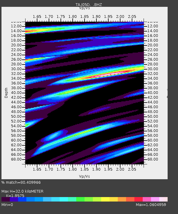
J05D Fort Rock, OR, USA - Earthquake Result Viewer

Earthquake location: Fox Islands, Aleutian Islands
Earthquake latitude/longitude: 52.8/-169.7
Earthquake time(UTC): 2010/07/18 (199) 19:48:04 GMT
Earthquake Depth: 10 km
Earthquake Magnitude: 5.6 MB, 5.6 MS, 6.0 MW, 6.0 MW
Earthquake Catalog/Contributor: WHDF/NEIC
Network: TA USArray Transportable Network (new EarthScope stations)
Station: J05D Fort Rock, OR, USA
Lat/Lon: 43.28 N/121.23 W
Elevation: 1541 m
Distance: 33.2 deg
Az: 86.86 deg
Baz: 303.908 deg
Ray Param: 0.078315556
Estimated Moho Depth: 32.0 km
Estimated Crust Vp/Vs: 1.96
Assumed Crust Vp: 6.597 km/s
Estimated Crust Vs: 3.37 km/s
Estimated Crust Poisson's Ratio: 0.32
Radial Match: 80.409966 %
Radial Bump: 400
Transverse Match: 59.501072 %
Transverse Bump: 400
SOD ConfigId: 319893
Insert Time: 2011-01-05 07:32:38.029 +0000
GWidth: 2.5
Max Bumps: 400
Tol: 0.001

Signal To Noise

ChannelStoNSTALTA
TA:J05D: :BHZ:20100718T19:54:10.700004Z9.4829759.683504E-71.0211462E-7
TA:J05D: :BHN:20100718T19:54:10.700004Z3.4088273.5560157E-71.0431787E-7
TA:J05D: :BHE:20100718T19:54:10.700004Z3.89248594.6405205E-71.192174E-7
Arrivals
Ps5.0 SECOND
PpPs13 SECOND
PsPs/PpSs18 SECOND