You are here: Home > Network List > TA - USArray Transportable Network (new EarthScope stations) Stations List
> Station V33A Lossen Ranch, Watonga, OK, USA > Earthquake Result Viewer
V33A Lossen Ranch, Watonga, OK, USA - Earthquake Result Viewer

| Earthquake location: |
Fox Islands, Aleutian Islands |
| Earthquake latitude/longitude: |
52.8/-169.7 |
| Earthquake time(UTC): |
2010/07/18 (199) 19:48:04 GMT |
| Earthquake Depth: |
10 km |
| Earthquake Magnitude: |
5.6 MB, 5.6 MS, 6.0 MW, 6.0 MW |
| Earthquake Catalog/Contributor: |
WHDF/NEIC |
|
| Network: |
TA USArray Transportable Network (new EarthScope stations) |
| Station: |
V33A Lossen Ranch, Watonga, OK, USA |
| Lat/Lon: |
35.82 N/98.29 W |
| Elevation: |
420 m |
|
| Distance: |
51.7 deg |
| Az: |
79.126 deg |
| Baz: |
312.825 deg |
| Ray Param: |
0.06725961 |
| Estimated Moho Depth: |
17.5 km |
| Estimated Crust Vp/Vs: |
1.88 |
| Assumed Crust Vp: |
6.315 km/s |
| Estimated Crust Vs: |
3.368 km/s |
| Estimated Crust Poisson's Ratio: |
0.30 |
|
| Radial Match: |
82.31383 % |
| Radial Bump: |
400 |
| Transverse Match: |
58.751945 % |
| Transverse Bump: |
400 |
| SOD ConfigId: |
319893 |
| Insert Time: |
2011-01-05 07:34:26.434 +0000 |
| GWidth: |
2.5 |
| Max Bumps: |
400 |
| Tol: |
0.001 |
|
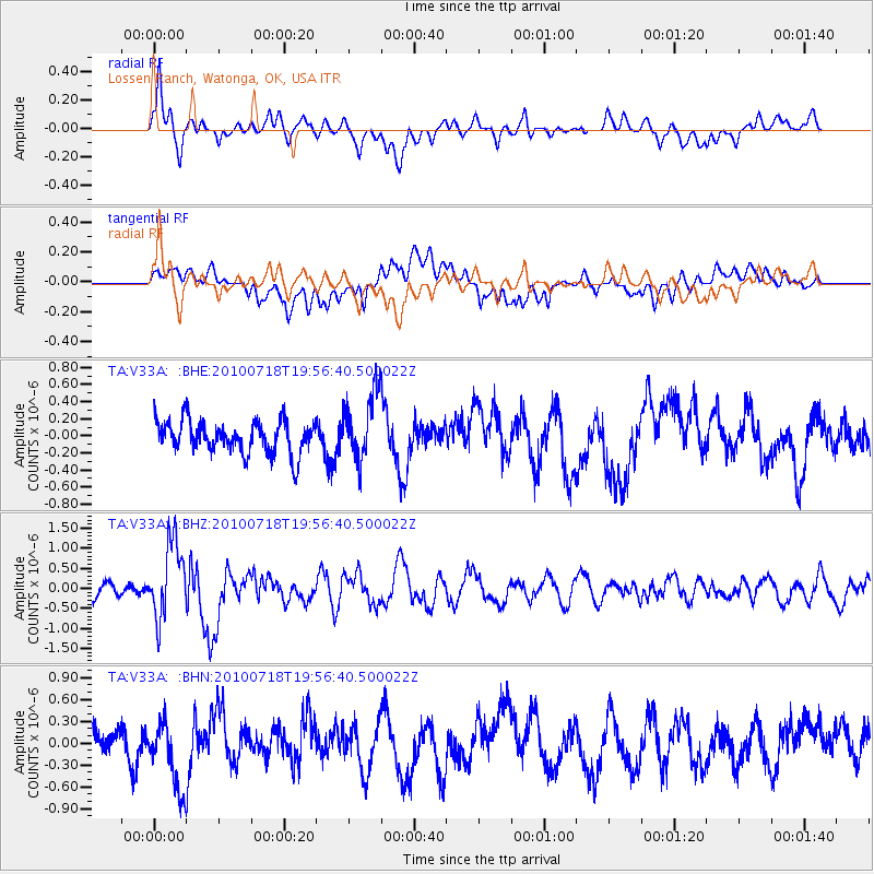
Signal To Noise
| Channel | StoN | STA | LTA |
| TA:V33A: :BHZ:20100718T19:56:40.500022Z | 6.669509 | 9.43098E-7 | 1.414044E-7 |
| TA:V33A: :BHN:20100718T19:56:40.500022Z | 3.2445443 | 4.829003E-7 | 1.4883457E-7 |
| TA:V33A: :BHE:20100718T19:56:40.500022Z | 2.1134882 | 3.9832338E-7 | 1.884673E-7 |
| Arrivals |
| Ps | 2.6 SECOND |
| PpPs | 7.6 SECOND |
| PsPs/PpSs | 10 SECOND |


