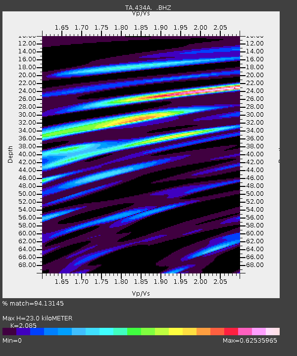
434A Burnet, TX, USA - Earthquake Result Viewer

Earthquake location: Fox Islands, Aleutian Islands
Earthquake latitude/longitude: 52.8/-169.7
Earthquake time(UTC): 2010/07/18 (199) 19:48:04 GMT
Earthquake Depth: 10 km
Earthquake Magnitude: 5.6 MB, 5.6 MS, 6.0 MW, 6.0 MW
Earthquake Catalog/Contributor: WHDF/NEIC
Network: TA USArray Transportable Network (new EarthScope stations)
Station: 434A Burnet, TX, USA
Lat/Lon: 30.81 N/98.27 W
Elevation: 462 m
Distance: 55.2 deg
Az: 83.574 deg
Baz: 315.488 deg
Ray Param: 0.06497382
Estimated Moho Depth: 23.0 km
Estimated Crust Vp/Vs: 2.09
Assumed Crust Vp: 6.498 km/s
Estimated Crust Vs: 3.116 km/s
Estimated Crust Poisson's Ratio: 0.35
Radial Match: 94.13145 %
Radial Bump: 400
Transverse Match: 73.47045 %
Transverse Bump: 400
SOD ConfigId: 319893
Insert Time: 2011-01-05 07:35:30.237 +0000
GWidth: 2.5
Max Bumps: 400
Tol: 0.001

Signal To Noise

ChannelStoNSTALTA
TA:434A: :BHZ:20100718T19:57:06.099998Z20.274111.403714E-66.923677E-8
TA:434A: :BHN:20100718T19:57:06.099998Z6.27488854.1295334E-76.581047E-8
TA:434A: :BHE:20100718T19:57:06.099998Z7.25273475.038862E-76.947534E-8
Arrivals
Ps4.0 SECOND
PpPs10 SECOND
PsPs/PpSs14 SECOND