You are here: Home > Network List > TA - USArray Transportable Network (new EarthScope stations) Stations List
> Station Z34A Collier Ranch, Chico, TX, USA > Earthquake Result Viewer
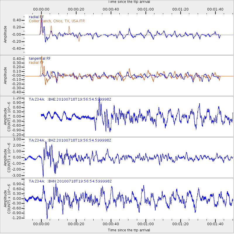
Z34A Collier Ranch, Chico, TX, USA - Earthquake Result Viewer
| Earthquake location: |
Fox Islands, Aleutian Islands |
| Earthquake latitude/longitude: |
52.8/-169.7 |
| Earthquake time(UTC): |
2010/07/18 (199) 19:48:04 GMT |
| Earthquake Depth: |
10 km |
| Earthquake Magnitude: |
5.6 MB, 5.6 MS, 6.0 MW, 6.0 MW |
| Earthquake Catalog/Contributor: |
WHDF/NEIC |
|
| Network: |
TA USArray Transportable Network (new EarthScope stations) |
| Station: |
Z34A Collier Ranch, Chico, TX, USA |
| Lat/Lon: |
33.37 N/97.92 W |
| Elevation: |
341 m |
|
| Distance: |
53.6 deg |
| Az: |
81.09 deg |
| Baz: |
314.227 deg |
| Ray Param: |
0.066005535 |
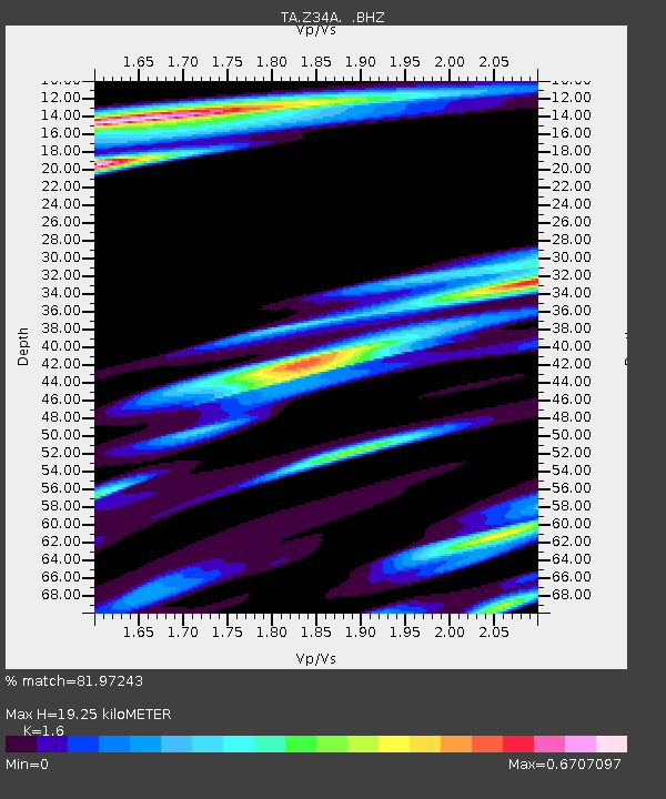
| Estimated Moho Depth: |
19.25 km |
| Estimated Crust Vp/Vs: |
1.60 |
| Assumed Crust Vp: |
6.38 km/s |
| Estimated Crust Vs: |
3.988 km/s |
| Estimated Crust Poisson's Ratio: |
0.18 |
|
| Radial Match: |
81.97243 % |
| Radial Bump: |
400 |
| Transverse Match: |
76.26937 % |
| Transverse Bump: |
400 |
| SOD ConfigId: |
319893 |
| Insert Time: |
2011-01-05 07:35:48.624 +0000 |
| GWidth: |
2.5 |
| Max Bumps: |
400 |
| Tol: |
0.001 |
|
Signal To Noise
| Channel | StoN | STA | LTA |
| TA:Z34A: :BHZ:20100718T19:56:54.599998Z | 10.289292 | 1.3162621E-6 | 1.2792542E-7 |
| TA:Z34A: :BHN:20100718T19:56:54.599998Z | 4.128466 | 4.8805657E-7 | 1.1821742E-7 |
| TA:Z34A: :BHE:20100718T19:56:54.599998Z | 3.183125 | 4.736618E-7 | 1.4880402E-7 |
| Arrivals |
| Ps | 1.9 SECOND |
| PpPs | 7.4 SECOND |
| PsPs/PpSs | 9.3 SECOND |


