335A Moody, TX, USA - Earthquake Result Viewer
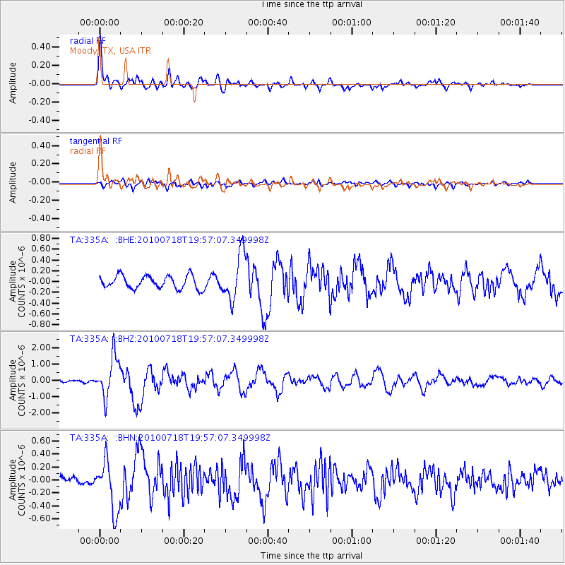
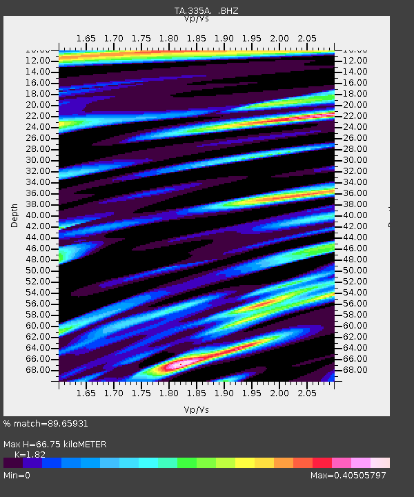
Earthquake location: Fox Islands, Aleutian Islands
Earthquake latitude/longitude: 52.8/-169.7
Earthquake time(UTC): 2010/07/18 (199) 19:48:04 GMT
Earthquake Depth: 10 km
Earthquake Magnitude: 5.6 MB, 5.6 MS, 6.0 MW, 6.0 MW
Earthquake Catalog/Contributor: WHDF/NEIC
Network: TA USArray Transportable Network (new EarthScope stations)
Station: 335A Moody, TX, USA
Lat/Lon: 31.28 N/97.43 W
Elevation: 217 m
Distance: 55.3 deg
Az: 82.549 deg
Baz: 315.336 deg
Ray Param: 0.064856924
Estimated Moho Depth: 66.75 km
Estimated Crust Vp/Vs: 1.82
Assumed Crust Vp: 6.347 km/s
Estimated Crust Vs: 3.487 km/s
Estimated Crust Poisson's Ratio: 0.28
Radial Match: 89.65931 %
Radial Bump: 400
Transverse Match: 64.9926 %
Transverse Bump: 400
SOD ConfigId: 319893
Insert Time: 2011-01-05 07:36:31.058 +0000
GWidth: 2.5
Max Bumps: 400
Tol: 0.001

Signal To Noise

ChannelStoNSTALTA
TA:335A: :BHZ:20100718T19:57:07.349998Z11.5651841.2755296E-61.1029048E-7
TA:335A: :BHN:20100718T19:57:07.349998Z5.84837153.983449E-76.811211E-8
TA:335A: :BHE:20100718T19:57:07.349998Z3.7442844.4219604E-71.1809896E-7
Arrivals
Ps9.1 SECOND
PpPs28 SECOND
PsPs/PpSs37 SECOND