You are here: Home > Network List > TA - USArray Transportable Network (new EarthScope stations) Stations List
> Station 633A Saathoff Ranch, Hondo, TX, USA > Earthquake Result Viewer
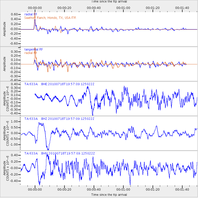
633A Saathoff Ranch, Hondo, TX, USA - Earthquake Result Viewer
*The percent match for this event was below the threshold and hence no stack was calculated.
| Earthquake location: |
Fox Islands, Aleutian Islands |
| Earthquake latitude/longitude: |
52.8/-169.7 |
| Earthquake time(UTC): |
2010/07/18 (199) 19:48:04 GMT |
| Earthquake Depth: |
10 km |
| Earthquake Magnitude: |
5.6 MB, 5.6 MS, 6.0 MW, 6.0 MW |
| Earthquake Catalog/Contributor: |
WHDF/NEIC |
|
| Network: |
TA USArray Transportable Network (new EarthScope stations) |
| Station: |
633A Saathoff Ranch, Hondo, TX, USA |
| Lat/Lon: |
29.46 N/99.18 W |
| Elevation: |
320 m |
|
| Distance: |
55.6 deg |
| Az: |
85.403 deg |
| Baz: |
316.074 deg |
| Ray Param: |
$rayparam |
*The percent match for this event was below the threshold and hence was not used in the summary stack. |
|
| Radial Match: |
73.037254 % |
| Radial Bump: |
400 |
| Transverse Match: |
63.519924 % |
| Transverse Bump: |
400 |
| SOD ConfigId: |
319893 |
| Insert Time: |
2011-01-05 07:37:04.714 +0000 |
| GWidth: |
2.5 |
| Max Bumps: |
400 |
| Tol: |
0.001 |
|
Signal To Noise
| Channel | StoN | STA | LTA |
| TA:633A: :BHZ:20100718T19:57:09.125022Z | 8.273958 | 6.590545E-7 | 7.965407E-8 |
| TA:633A: :BHN:20100718T19:57:09.125022Z | 4.9627724 | 2.752436E-7 | 5.5461662E-8 |
| TA:633A: :BHE:20100718T19:57:09.125022Z | 1.3506881 | 9.6768034E-8 | 7.1643505E-8 |
| Arrivals |
| Ps | |
| PpPs | |
| PsPs/PpSs | |


