You are here: Home > Network List > AK - Alaska Regional Network Stations List
> Station G17K Kiwalik Mountain, AK, USA > Earthquake Result Viewer
G17K Kiwalik Mountain, AK, USA - Earthquake Result Viewer
| Earthquake location: |
Vanuatu Islands |
| Earthquake latitude/longitude: |
-14.0/167.2 |
| Earthquake time(UTC): |
2023/09/21 (264) 21:11:49 GMT |
| Earthquake Depth: |
188 km |
| Earthquake Magnitude: |
6.1 mww |
| Earthquake Catalog/Contributor: |
NEIC PDE/us |
|
| Network: |
AK Alaska Regional Network |
| Station: |
G17K Kiwalik Mountain, AK, USA |
| Lat/Lon: |
65.50 N/160.65 W |
| Elevation: |
338 m |
|
| Distance: |
82.9 deg |
| Az: |
12.925 deg |
| Baz: |
211.378 deg |
| Ray Param: |
0.046136502 |
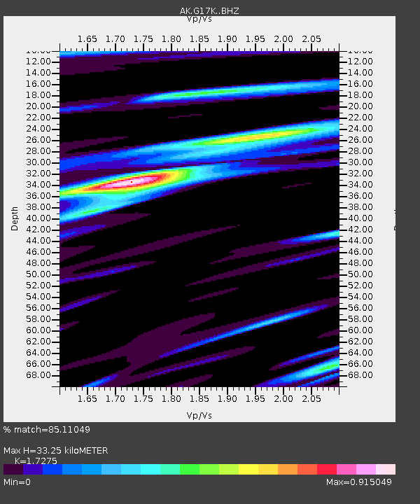
| Estimated Moho Depth: |
33.25 km |
| Estimated Crust Vp/Vs: |
1.73 |
| Assumed Crust Vp: |
6.276 km/s |
| Estimated Crust Vs: |
3.633 km/s |
| Estimated Crust Poisson's Ratio: |
0.25 |
|
| Radial Match: |
85.11049 % |
| Radial Bump: |
324 |
| Transverse Match: |
70.63388 % |
| Transverse Bump: |
400 |
| SOD ConfigId: |
31937991 |
| Insert Time: |
2023-10-05 21:14:42.811 +0000 |
| GWidth: |
2.5 |
| Max Bumps: |
400 |
| Tol: |
0.001 |
|

Signal To Noise
| Channel | StoN | STA | LTA |
| AK:G17K: :BHZ:20230921T21:23:22.160022Z | 12.984009 | 1.5595725E-6 | 1.2011486E-7 |
| AK:G17K: :BHN:20230921T21:23:22.160022Z | 3.4226751 | 4.0579792E-7 | 1.1856162E-7 |
| AK:G17K: :BHE:20230921T21:23:22.160022Z | 3.3965094 | 3.4607268E-7 | 1.0189069E-7 |
| Arrivals |
| Ps | 4.0 SECOND |
| PpPs | 14 SECOND |
| PsPs/PpSs | 18 SECOND |


