You are here: Home > Network List > TA - USArray Transportable Network (new EarthScope stations) Stations List
> Station 436A Wall Ranch, Gause, TX, USA > Earthquake Result Viewer
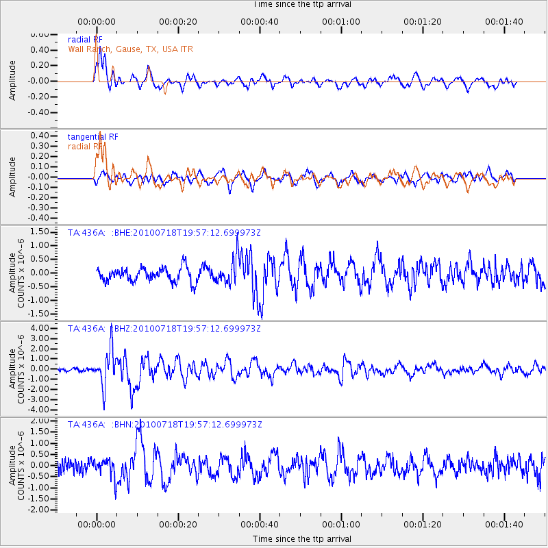
436A Wall Ranch, Gause, TX, USA - Earthquake Result Viewer
| Earthquake location: |
Fox Islands, Aleutian Islands |
| Earthquake latitude/longitude: |
52.8/-169.7 |
| Earthquake time(UTC): |
2010/07/18 (199) 19:48:04 GMT |
| Earthquake Depth: |
10 km |
| Earthquake Magnitude: |
5.6 MB, 5.6 MS, 6.0 MW, 6.0 MW |
| Earthquake Catalog/Contributor: |
WHDF/NEIC |
|
| Network: |
TA USArray Transportable Network (new EarthScope stations) |
| Station: |
436A Wall Ranch, Gause, TX, USA |
| Lat/Lon: |
30.77 N/96.80 W |
| Elevation: |
109 m |
|
| Distance: |
56.1 deg |
| Az: |
82.515 deg |
| Baz: |
315.64 deg |
| Ray Param: |
0.06437271 |
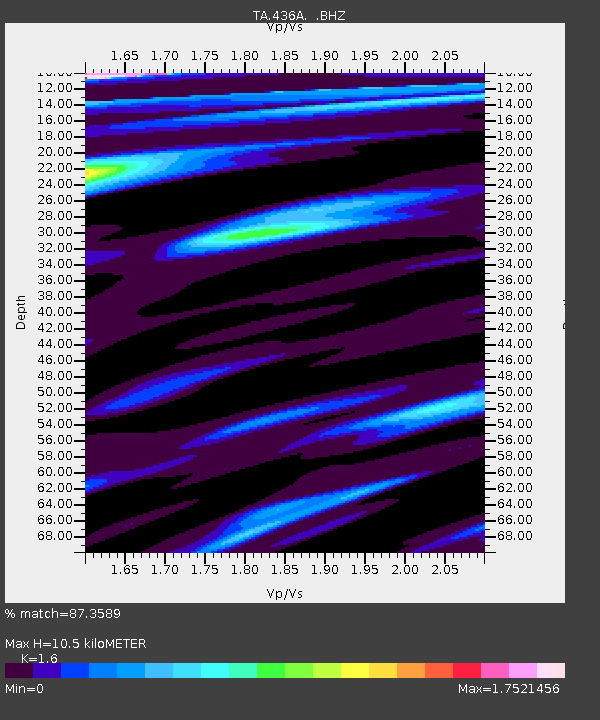
| Estimated Moho Depth: |
10.5 km |
| Estimated Crust Vp/Vs: |
1.60 |
| Assumed Crust Vp: |
6.347 km/s |
| Estimated Crust Vs: |
3.967 km/s |
| Estimated Crust Poisson's Ratio: |
0.18 |
|
| Radial Match: |
87.3589 % |
| Radial Bump: |
400 |
| Transverse Match: |
60.57269 % |
| Transverse Bump: |
400 |
| SOD ConfigId: |
319893 |
| Insert Time: |
2011-01-05 07:38:35.100 +0000 |
| GWidth: |
2.5 |
| Max Bumps: |
400 |
| Tol: |
0.001 |
|
Signal To Noise
| Channel | StoN | STA | LTA |
| TA:436A: :BHZ:20100718T19:57:12.699973Z | 14.058281 | 1.7833579E-6 | 1.2685462E-7 |
| TA:436A: :BHN:20100718T19:57:12.699973Z | 1.9681226 | 4.2492766E-7 | 2.1590508E-7 |
| TA:436A: :BHE:20100718T19:57:12.699973Z | 1.9094907 | 4.80719E-7 | 2.5175245E-7 |
| Arrivals |
| Ps | 1.0 SECOND |
| PpPs | 4.1 SECOND |
| PsPs/PpSs | 5.1 SECOND |


