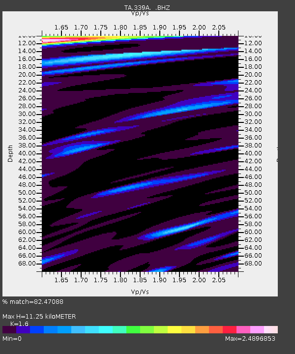
339A Huntington, TX, USA - Earthquake Result Viewer
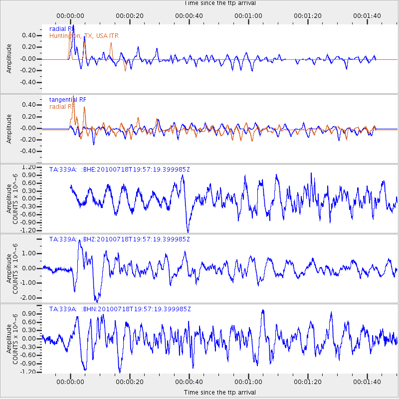
Earthquake location: Fox Islands, Aleutian Islands
Earthquake latitude/longitude: 52.8/-169.7
Earthquake time(UTC): 2010/07/18 (199) 19:48:04 GMT
Earthquake Depth: 10 km
Earthquake Magnitude: 5.6 MB, 5.6 MS, 6.0 MW, 6.0 MW
Earthquake Catalog/Contributor: WHDF/NEIC
Network: TA USArray Transportable Network (new EarthScope stations)
Station: 339A Huntington, TX, USA
Lat/Lon: 31.33 N/94.56 W
Elevation: 82 m
Distance: 57.0 deg
Az: 80.397 deg
Baz: 315.623 deg
Ray Param: 0.06375561
Estimated Moho Depth: 11.25 km
Estimated Crust Vp/Vs: 1.60
Assumed Crust Vp: 5.738 km/s
Estimated Crust Vs: 3.587 km/s
Estimated Crust Poisson's Ratio: 0.18
Radial Match: 82.47088 %
Radial Bump: 400
Transverse Match: 51.203793 %
Transverse Bump: 400
SOD ConfigId: 319893
Insert Time: 2011-01-05 07:39:04.030 +0000
GWidth: 2.5
Max Bumps: 400
Tol: 0.001

Signal To Noise

ChannelStoNSTALTA
TA:339A: :BHZ:20100718T19:57:19.399985Z9.5917221.0109959E-61.0540296E-7
TA:339A: :BHN:20100718T19:57:19.399985Z3.6732625.5984975E-71.5241216E-7
TA:339A: :BHE:20100718T19:57:19.399985Z0.805145262.3372758E-72.9029243E-7
Arrivals
Ps1.2 SECOND
PpPs4.9 SECOND
PsPs/PpSs6.1 SECOND