You are here: Home > Network List > TA - USArray Transportable Network (new EarthScope stations) Stations List
> Station X37A Clayton, OK, USA > Earthquake Result Viewer
X37A Clayton, OK, USA - Earthquake Result Viewer
*The percent match for this event was below the threshold and hence no stack was calculated.
| Earthquake location: |
Fox Islands, Aleutian Islands |
| Earthquake latitude/longitude: |
52.8/-169.7 |
| Earthquake time(UTC): |
2010/07/18 (199) 19:48:04 GMT |
| Earthquake Depth: |
10 km |
| Earthquake Magnitude: |
5.6 MB, 5.6 MS, 6.0 MW, 6.0 MW |
| Earthquake Catalog/Contributor: |
WHDF/NEIC |
|
| Network: |
TA USArray Transportable Network (new EarthScope stations) |
| Station: |
X37A Clayton, OK, USA |
| Lat/Lon: |
34.59 N/95.37 W |
| Elevation: |
207 m |
|
| Distance: |
54.3 deg |
| Az: |
78.19 deg |
| Baz: |
313.935 deg |
| Ray Param: |
$rayparam |
*The percent match for this event was below the threshold and hence was not used in the summary stack. |
|
| Radial Match: |
77.74429 % |
| Radial Bump: |
400 |
| Transverse Match: |
60.020184 % |
| Transverse Bump: |
400 |
| SOD ConfigId: |
319893 |
| Insert Time: |
2011-01-05 07:40:52.152 +0000 |
| GWidth: |
2.5 |
| Max Bumps: |
400 |
| Tol: |
0.001 |
|
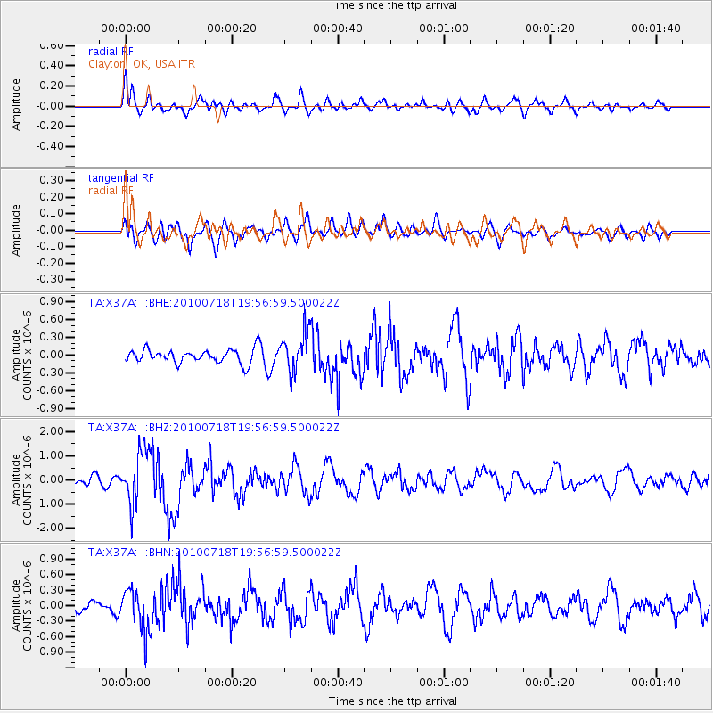
Signal To Noise
| Channel | StoN | STA | LTA |
| TA:X37A: :BHZ:20100718T19:56:59.500022Z | 5.312735 | 1.1128742E-6 | 2.0947293E-7 |
| TA:X37A: :BHN:20100718T19:56:59.500022Z | 2.246535 | 4.1003824E-7 | 1.8252028E-7 |
| TA:X37A: :BHE:20100718T19:56:59.500022Z | 3.0716615 | 3.3746605E-7 | 1.0986433E-7 |
| Arrivals |
| Ps | |
| PpPs | |
| PsPs/PpSs | |


