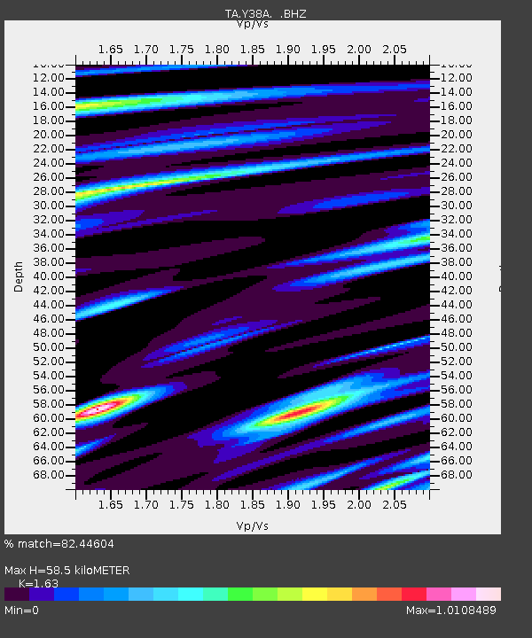
Y38A Idabel, OK, USA - Earthquake Result Viewer
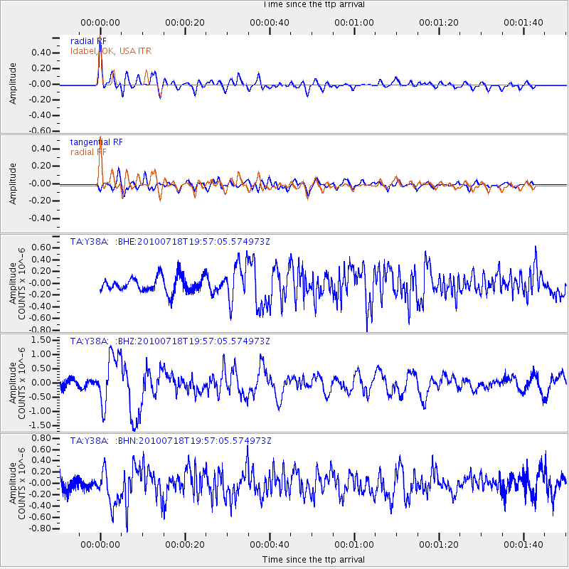
Earthquake location: Fox Islands, Aleutian Islands
Earthquake latitude/longitude: 52.8/-169.7
Earthquake time(UTC): 2010/07/18 (199) 19:48:04 GMT
Earthquake Depth: 10 km
Earthquake Magnitude: 5.6 MB, 5.6 MS, 6.0 MW, 6.0 MW
Earthquake Catalog/Contributor: WHDF/NEIC
Network: TA USArray Transportable Network (new EarthScope stations)
Station: Y38A Idabel, OK, USA
Lat/Lon: 33.93 N/94.73 W
Elevation: 118 m
Distance: 55.1 deg
Az: 78.318 deg
Baz: 314.367 deg
Ray Param: 0.06502195
Estimated Moho Depth: 58.5 km
Estimated Crust Vp/Vs: 1.63
Assumed Crust Vp: 6.245 km/s
Estimated Crust Vs: 3.831 km/s
Estimated Crust Poisson's Ratio: 0.20
Radial Match: 82.44604 %
Radial Bump: 400
Transverse Match: 67.12482 %
Transverse Bump: 400
SOD ConfigId: 319893
Insert Time: 2011-01-05 07:41:29.889 +0000
GWidth: 2.5
Max Bumps: 400
Tol: 0.001

Signal To Noise

ChannelStoNSTALTA
TA:Y38A: :BHZ:20100718T19:57:05.574973Z7.62914668.868003E-71.1623847E-7
TA:Y38A: :BHN:20100718T19:57:05.574973Z2.72571663.2489768E-71.1919716E-7
TA:Y38A: :BHE:20100718T19:57:05.574973Z2.47606563.2176243E-71.2994907E-7
Arrivals
Ps6.2 SECOND
PpPs23 SECOND
PsPs/PpSs30 SECOND