You are here: Home > Network List > US - United States National Seismic Network Stations List
> Station DGMT Dagmar, Montana, USA > Earthquake Result Viewer
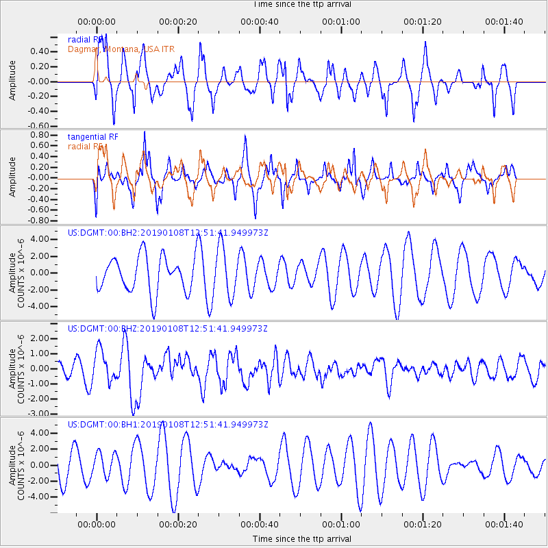
DGMT Dagmar, Montana, USA - Earthquake Result Viewer
*The percent match for this event was below the threshold and hence no stack was calculated.
| Earthquake location: |
Kyushu, Japan |
| Earthquake latitude/longitude: |
30.6/131.0 |
| Earthquake time(UTC): |
2019/01/08 (008) 12:39:31 GMT |
| Earthquake Depth: |
35 km |
| Earthquake Magnitude: |
6.3 Mww |
| Earthquake Catalog/Contributor: |
NEIC PDE/us |
|
| Network: |
US United States National Seismic Network |
| Station: |
DGMT Dagmar, Montana, USA |
| Lat/Lon: |
48.47 N/104.20 W |
| Elevation: |
0.0 m |
|
| Distance: |
87.1 deg |
| Az: |
33.189 deg |
| Baz: |
314.825 deg |
| Ray Param: |
$rayparam |
*The percent match for this event was below the threshold and hence was not used in the summary stack. |
|
| Radial Match: |
57.442062 % |
| Radial Bump: |
363 |
| Transverse Match: |
58.17805 % |
| Transverse Bump: |
379 |
| SOD ConfigId: |
3257111 |
| Insert Time: |
2019-01-22 12:51:52.474 +0000 |
| GWidth: |
2.5 |
| Max Bumps: |
400 |
| Tol: |
0.001 |
|
Signal To Noise
| Channel | StoN | STA | LTA |
| US:DGMT:00:BHZ:20190108T12:51:41.949973Z | 1.8629146 | 1.0573028E-6 | 5.6755306E-7 |
| US:DGMT:00:BH1:20190108T12:51:41.949973Z | 0.60285693 | 1.4489481E-6 | 2.4034691E-6 |
| US:DGMT:00:BH2:20190108T12:51:41.949973Z | 1.3624954 | 2.9104306E-6 | 2.136103E-6 |
| Arrivals |
| Ps | |
| PpPs | |
| PsPs/PpSs | |


