You are here: Home > Network List > TA - USArray Transportable Network (new EarthScope stations) Stations List
> Station P36A Good Intent, Atchison, KS, USA > Earthquake Result Viewer
P36A Good Intent, Atchison, KS, USA - Earthquake Result Viewer

| Earthquake location: |
Fox Islands, Aleutian Islands |
| Earthquake latitude/longitude: |
52.8/-169.7 |
| Earthquake time(UTC): |
2010/07/18 (199) 19:48:04 GMT |
| Earthquake Depth: |
10 km |
| Earthquake Magnitude: |
5.6 MB, 5.6 MS, 6.0 MW, 6.0 MW |
| Earthquake Catalog/Contributor: |
WHDF/NEIC |
|
| Network: |
TA USArray Transportable Network (new EarthScope stations) |
| Station: |
P36A Good Intent, Atchison, KS, USA |
| Lat/Lon: |
39.62 N/95.21 W |
| Elevation: |
313 m |
|
| Distance: |
51.0 deg |
| Az: |
73.42 deg |
| Baz: |
311.135 deg |
| Ray Param: |
0.06771704 |
| Estimated Moho Depth: |
18.75 km |
| Estimated Crust Vp/Vs: |
1.70 |
| Assumed Crust Vp: |
6.498 km/s |
| Estimated Crust Vs: |
3.828 km/s |
| Estimated Crust Poisson's Ratio: |
0.23 |
|
| Radial Match: |
83.56177 % |
| Radial Bump: |
400 |
| Transverse Match: |
60.569157 % |
| Transverse Bump: |
400 |
| SOD ConfigId: |
319893 |
| Insert Time: |
2011-01-05 07:43:22.074 +0000 |
| GWidth: |
2.5 |
| Max Bumps: |
400 |
| Tol: |
0.001 |
|
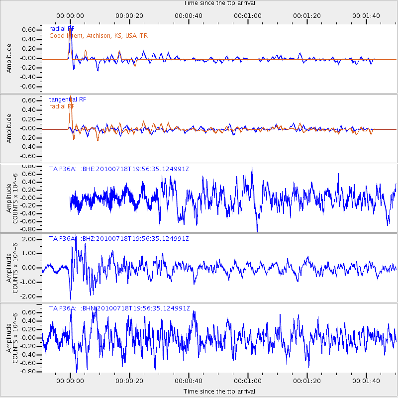
Signal To Noise
| Channel | StoN | STA | LTA |
| TA:P36A: :BHZ:20100718T19:56:35.124991Z | 8.327173 | 1.0182829E-6 | 1.2228433E-7 |
| TA:P36A: :BHN:20100718T19:56:35.124991Z | 2.7182345 | 3.434329E-7 | 1.263441E-7 |
| TA:P36A: :BHE:20100718T19:56:35.124991Z | 2.1258836 | 3.1042123E-7 | 1.4601987E-7 |
| Arrivals |
| Ps | 2.1 SECOND |
| PpPs | 7.3 SECOND |
| PsPs/PpSs | 9.5 SECOND |


