M35A Neola, IA, USA - Earthquake Result Viewer
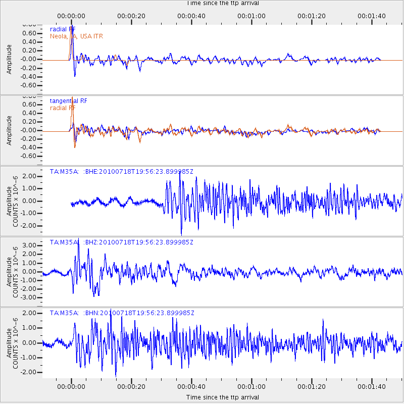
Earthquake location: Fox Islands, Aleutian Islands
Earthquake latitude/longitude: 52.8/-169.7
Earthquake time(UTC): 2010/07/18 (199) 19:48:04 GMT
Earthquake Depth: 10 km
Earthquake Magnitude: 5.6 MB, 5.6 MS, 6.0 MW, 6.0 MW
Earthquake Catalog/Contributor: WHDF/NEIC
Network: TA USArray Transportable Network (new EarthScope stations)
Station: M35A Neola, IA, USA
Lat/Lon: 41.47 N/95.69 W
Elevation: 363 m
Distance: 49.5 deg
Az: 71.91 deg
Baz: 309.852 deg
Ray Param: 0.068678565
Estimated Moho Depth: 33.25 km
Estimated Crust Vp/Vs: 1.87
Assumed Crust Vp: 6.498 km/s
Estimated Crust Vs: 3.479 km/s
Estimated Crust Poisson's Ratio: 0.30
Radial Match: 85.79715 %
Radial Bump: 400
Transverse Match: 68.55409 %
Transverse Bump: 400
SOD ConfigId: 319893
Insert Time: 2011-01-05 07:44:08.465 +0000
GWidth: 2.5
Max Bumps: 400
Tol: 0.001

Signal To Noise

ChannelStoNSTALTA
TA:M35A: :BHZ:20100718T19:56:23.899985Z6.0870531.23572E-62.0300794E-7
TA:M35A: :BHN:20100718T19:56:23.899985Z5.67658047.654079E-71.3483609E-7
TA:M35A: :BHE:20100718T19:56:23.899985Z4.46255877.9325116E-71.7775703E-7
Arrivals
Ps4.7 SECOND
PpPs14 SECOND
PsPs/PpSs19 SECOND