You are here: Home > Network List > IU - Global Seismograph Network (GSN - IRIS/USGS) Stations List
> Station PMG Port Moresby, New Guinea > Earthquake Result Viewer
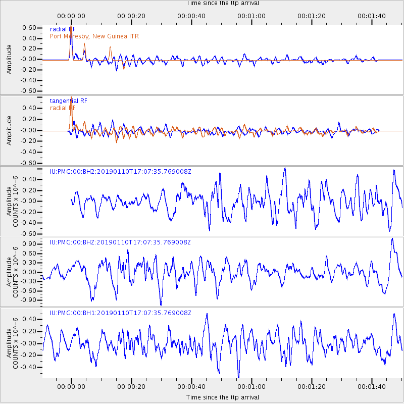
PMG Port Moresby, New Guinea - Earthquake Result Viewer
*The percent match for this event was below the threshold and hence no stack was calculated.
| Earthquake location: |
South Of Tonga Islands |
| Earthquake latitude/longitude: |
-26.9/-175.5 |
| Earthquake time(UTC): |
2019/01/10 (010) 17:00:37 GMT |
| Earthquake Depth: |
10 km |
| Earthquake Magnitude: |
5.8 Mww |
| Earthquake Catalog/Contributor: |
NEIC PDE/us |
|
| Network: |
IU Global Seismograph Network (GSN - IRIS/USGS) |
| Station: |
PMG Port Moresby, New Guinea |
| Lat/Lon: |
9.40 S/147.16 E |
| Elevation: |
90 m |
|
| Distance: |
39.3 deg |
| Az: |
289.18 deg |
| Baz: |
121.274 deg |
| Ray Param: |
$rayparam |
*The percent match for this event was below the threshold and hence was not used in the summary stack. |
|
| Radial Match: |
64.41241 % |
| Radial Bump: |
400 |
| Transverse Match: |
67.4692 % |
| Transverse Bump: |
400 |
| SOD ConfigId: |
3257111 |
| Insert Time: |
2019-01-24 17:14:53.751 +0000 |
| GWidth: |
2.5 |
| Max Bumps: |
400 |
| Tol: |
0.001 |
|
Signal To Noise
| Channel | StoN | STA | LTA |
| IU:PMG:00:BHZ:20190110T17:07:35.769008Z | 1.945784 | 2.2947883E-7 | 1.1793644E-7 |
| IU:PMG:00:BH1:20190110T17:07:35.769008Z | 0.9029314 | 1.2348562E-7 | 1.367608E-7 |
| IU:PMG:00:BH2:20190110T17:07:35.769008Z | 1.9752789 | 2.051297E-7 | 1.0384847E-7 |
| Arrivals |
| Ps | |
| PpPs | |
| PsPs/PpSs | |


