You are here: Home > Network List > UW - Pacific Northwest Regional Seismic Network Stations List
> Station LCCR Mulino, OR, USA > Earthquake Result Viewer
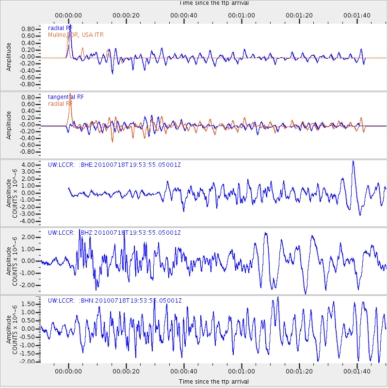
LCCR Mulino, OR, USA - Earthquake Result Viewer
*The percent match for this event was below the threshold and hence no stack was calculated.
| Earthquake location: |
Fox Islands, Aleutian Islands |
| Earthquake latitude/longitude: |
52.8/-169.7 |
| Earthquake time(UTC): |
2010/07/18 (199) 19:48:04 GMT |
| Earthquake Depth: |
10 km |
| Earthquake Magnitude: |
5.6 MB, 5.6 MS, 6.0 MW, 6.0 MW |
| Earthquake Catalog/Contributor: |
WHDF/NEIC |
|
| Network: |
UW Pacific Northwest Regional Seismic Network |
| Station: |
LCCR Mulino, OR, USA |
| Lat/Lon: |
45.21 N/122.48 W |
| Elevation: |
273 m |
|
| Distance: |
31.4 deg |
| Az: |
84.732 deg |
| Baz: |
301.245 deg |
| Ray Param: |
$rayparam |
*The percent match for this event was below the threshold and hence was not used in the summary stack. |
|
| Radial Match: |
79.40935 % |
| Radial Bump: |
400 |
| Transverse Match: |
62.776066 % |
| Transverse Bump: |
400 |
| SOD ConfigId: |
319893 |
| Insert Time: |
2011-01-05 07:49:38.021 +0000 |
| GWidth: |
2.5 |
| Max Bumps: |
400 |
| Tol: |
0.001 |
|
Signal To Noise
| Channel | StoN | STA | LTA |
| UW:LCCR: :BHZ:20100718T19:53:55.05001Z | 5.7469115 | 9.550764E-7 | 1.6618951E-7 |
| UW:LCCR: :BHN:20100718T19:53:55.05001Z | 1.4524604 | 4.8083996E-7 | 3.31052E-7 |
| UW:LCCR: :BHE:20100718T19:53:55.05001Z | 2.4032276 | 6.862043E-7 | 2.8553447E-7 |
| Arrivals |
| Ps | |
| PpPs | |
| PsPs/PpSs | |


