You are here: Home > Network List > AV - Alaska Volcano Observatory Stations List
> Station MAPS Pakushin Southeast, Makushin Volcano, Alaska > Earthquake Result Viewer
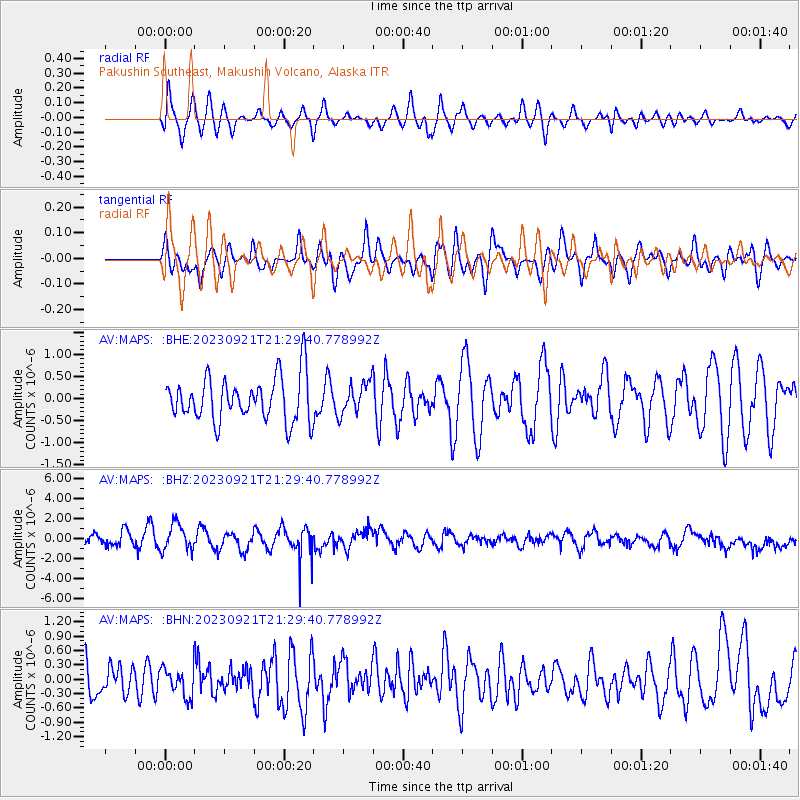
MAPS Pakushin Southeast, Makushin Volcano, Alaska - Earthquake Result Viewer
*The percent match for this event was below the threshold and hence no stack was calculated.
| Earthquake location: |
Southeast Of Honshu, Japan |
| Earthquake latitude/longitude: |
31.0/141.8 |
| Earthquake time(UTC): |
2023/09/21 (264) 21:22:12 GMT |
| Earthquake Depth: |
13 km |
| Earthquake Magnitude: |
5.7 Mww |
| Earthquake Catalog/Contributor: |
NEIC PDE/us |
|
| Network: |
AV Alaska Volcano Observatory |
| Station: |
MAPS Pakushin Southeast, Makushin Volcano, Alaska |
| Lat/Lon: |
53.81 N/166.94 W |
| Elevation: |
333 m |
|
| Distance: |
43.0 deg |
| Az: |
42.672 deg |
| Baz: |
259.05 deg |
| Ray Param: |
$rayparam |
*The percent match for this event was below the threshold and hence was not used in the summary stack. |
|
| Radial Match: |
56.53973 % |
| Radial Bump: |
400 |
| Transverse Match: |
51.5866 % |
| Transverse Bump: |
400 |
| SOD ConfigId: |
31937991 |
| Insert Time: |
2023-10-05 21:46:47.055 +0000 |
| GWidth: |
2.5 |
| Max Bumps: |
400 |
| Tol: |
0.001 |
|
Signal To Noise
| Channel | StoN | STA | LTA |
| AV:MAPS: :BHZ:20230921T21:29:40.778992Z | 2.4187577 | 1.325192E-6 | 5.4788126E-7 |
| AV:MAPS: :BHN:20230921T21:29:40.778992Z | 0.86363715 | 3.1810333E-7 | 3.6832986E-7 |
| AV:MAPS: :BHE:20230921T21:29:40.778992Z | 0.73641306 | 3.693134E-7 | 5.0150305E-7 |
| Arrivals |
| Ps | |
| PpPs | |
| PsPs/PpSs | |


