You are here: Home > Network List > IU - Global Seismograph Network (GSN - IRIS/USGS) Stations List
> Station CTAO Charters Towers, Australia > Earthquake Result Viewer
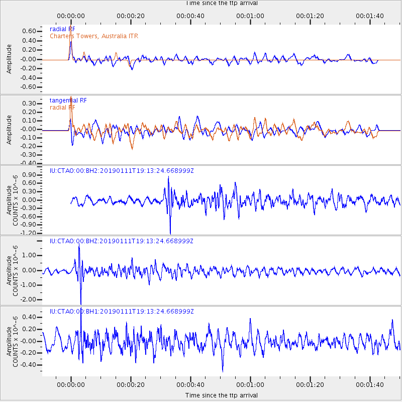
CTAO Charters Towers, Australia - Earthquake Result Viewer
*The percent match for this event was below the threshold and hence no stack was calculated.
| Earthquake location: |
Southern Sumatra, Indonesia |
| Earthquake latitude/longitude: |
-3.4/101.3 |
| Earthquake time(UTC): |
2019/01/11 (011) 19:05:29 GMT |
| Earthquake Depth: |
39 km |
| Earthquake Magnitude: |
5.4 Mww |
| Earthquake Catalog/Contributor: |
NEIC PDE/us |
|
| Network: |
IU Global Seismograph Network (GSN - IRIS/USGS) |
| Station: |
CTAO Charters Towers, Australia |
| Lat/Lon: |
20.09 S/146.25 E |
| Elevation: |
357 m |
|
| Distance: |
46.8 deg |
| Az: |
114.439 deg |
| Baz: |
284.775 deg |
| Ray Param: |
$rayparam |
*The percent match for this event was below the threshold and hence was not used in the summary stack. |
|
| Radial Match: |
59.836597 % |
| Radial Bump: |
400 |
| Transverse Match: |
57.899815 % |
| Transverse Bump: |
400 |
| SOD ConfigId: |
3257111 |
| Insert Time: |
2019-01-25 19:14:41.761 +0000 |
| GWidth: |
2.5 |
| Max Bumps: |
400 |
| Tol: |
0.001 |
|
Signal To Noise
| Channel | StoN | STA | LTA |
| IU:CTAO:00:BHZ:20190111T19:13:24.668999Z | 3.8024023 | 6.750724E-7 | 1.7753841E-7 |
| IU:CTAO:00:BH1:20190111T19:13:24.668999Z | 1.6819934 | 1.7252383E-7 | 1.0257105E-7 |
| IU:CTAO:00:BH2:20190111T19:13:24.668999Z | 3.8089454 | 3.6011645E-7 | 9.454492E-8 |
| Arrivals |
| Ps | |
| PpPs | |
| PsPs/PpSs | |


