You are here: Home > Network List > PS - Pacific21 Stations List
> Station INU Inuyama, Japan > Earthquake Result Viewer
INU Inuyama, Japan - Earthquake Result Viewer
| Earthquake location: |
Banda Sea |
| Earthquake latitude/longitude: |
-7.1/129.7 |
| Earthquake time(UTC): |
2023/09/22 (265) 14:59:17 GMT |
| Earthquake Depth: |
161 km |
| Earthquake Magnitude: |
5.7 mww |
| Earthquake Catalog/Contributor: |
NEIC PDE/us |
|
| Network: |
PS Pacific21 |
| Station: |
INU Inuyama, Japan |
| Lat/Lon: |
35.35 N/137.03 E |
| Elevation: |
132 m |
|
| Distance: |
42.8 deg |
| Az: |
8.809 deg |
| Baz: |
190.714 deg |
| Ray Param: |
0.072330356 |
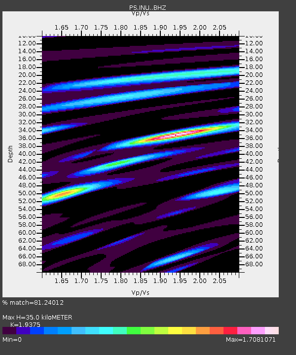
| Estimated Moho Depth: |
35.0 km |
| Estimated Crust Vp/Vs: |
1.94 |
| Assumed Crust Vp: |
6.461 km/s |
| Estimated Crust Vs: |
3.335 km/s |
| Estimated Crust Poisson's Ratio: |
0.32 |
|
| Radial Match: |
81.24012 % |
| Radial Bump: |
400 |
| Transverse Match: |
59.867794 % |
| Transverse Bump: |
400 |
| SOD ConfigId: |
31937991 |
| Insert Time: |
2023-10-06 15:07:55.394 +0000 |
| GWidth: |
2.5 |
| Max Bumps: |
400 |
| Tol: |
0.001 |
|

Signal To Noise
| Channel | StoN | STA | LTA |
| PS:INU: :BHZ:20230922T15:06:29.011Z | 2.0837367 | 2.4032252E-7 | 1.15332476E-7 |
| PS:INU: :BHN:20230922T15:06:29.011Z | 1.7852231 | 2.4456364E-7 | 1.3699332E-7 |
| PS:INU: :BHE:20230922T15:06:29.011Z | 1.7878233 | 1.3504555E-7 | 7.55363E-8 |
| Arrivals |
| Ps | 5.4 SECOND |
| PpPs | 15 SECOND |
| PsPs/PpSs | 20 SECOND |


