You are here: Home > Network List > TM - Thai Seismic Monitoring Network Stations List
> Station PANO PANO staion > Earthquake Result Viewer
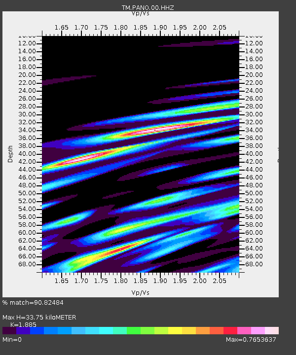
PANO PANO staion - Earthquake Result Viewer
| Earthquake location: |
Banda Sea |
| Earthquake latitude/longitude: |
-7.1/129.7 |
| Earthquake time(UTC): |
2023/09/22 (265) 14:59:17 GMT |
| Earthquake Depth: |
161 km |
| Earthquake Magnitude: |
5.7 mww |
| Earthquake Catalog/Contributor: |
NEIC PDE/us |
|
| Network: |
TM Thai Seismic Monitoring Network |
| Station: |
PANO PANO staion |
| Lat/Lon: |
17.15 N/104.61 E |
| Elevation: |
136 m |
|
| Distance: |
34.6 deg |
| Az: |
314.436 deg |
| Baz: |
132.174 deg |
| Ray Param: |
0.07709488 |
| Estimated Moho Depth: |
33.75 km |
| Estimated Crust Vp/Vs: |
1.88 |
| Assumed Crust Vp: |
6.498 km/s |
| Estimated Crust Vs: |
3.447 km/s |
| Estimated Crust Poisson's Ratio: |
0.30 |
|
| Radial Match: |
90.82484 % |
| Radial Bump: |
400 |
| Transverse Match: |
82.60466 % |
| Transverse Bump: |
400 |
| SOD ConfigId: |
31937991 |
| Insert Time: |
2023-10-06 15:08:57.264 +0000 |
| GWidth: |
2.5 |
| Max Bumps: |
400 |
| Tol: |
0.001 |
|

Signal To Noise
| Channel | StoN | STA | LTA |
| TM:PANO:00:HHZ:20230922T15:05:20.84001Z | 110.35349 | 1.0164756E-6 | 9.211087E-9 |
| TM:PANO:00:HHN:20230922T15:05:20.84001Z | 27.593557 | 2.1406933E-7 | 7.757946E-9 |
| TM:PANO:00:HHE:20230922T15:05:20.84001Z | 66.893906 | 4.124493E-7 | 6.165723E-9 |
| Arrivals |
| Ps | 4.9 SECOND |
| PpPs | 14 SECOND |
| PsPs/PpSs | 19 SECOND |


