You are here: Home > Network List > AK - Alaska Regional Network Stations List
> Station F15K North Star Ditch, AK, USA > Earthquake Result Viewer
F15K North Star Ditch, AK, USA - Earthquake Result Viewer
| Earthquake location: |
Talaud Islands, Indonesia |
| Earthquake latitude/longitude: |
4.7/127.5 |
| Earthquake time(UTC): |
2023/09/26 (269) 01:39:44 GMT |
| Earthquake Depth: |
100 km |
| Earthquake Magnitude: |
5.9 mww |
| Earthquake Catalog/Contributor: |
NEIC PDE/us |
|
| Network: |
AK Alaska Regional Network |
| Station: |
F15K North Star Ditch, AK, USA |
| Lat/Lon: |
65.71 N/164.65 W |
| Elevation: |
388 m |
|
| Distance: |
76.7 deg |
| Az: |
23.186 deg |
| Baz: |
251.537 deg |
| Ray Param: |
0.050589338 |
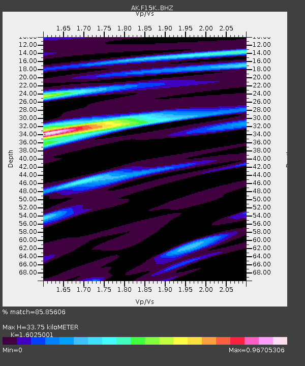
| Estimated Moho Depth: |
33.75 km |
| Estimated Crust Vp/Vs: |
1.60 |
| Assumed Crust Vp: |
6.276 km/s |
| Estimated Crust Vs: |
3.916 km/s |
| Estimated Crust Poisson's Ratio: |
0.18 |
|
| Radial Match: |
85.85606 % |
| Radial Bump: |
400 |
| Transverse Match: |
68.65035 % |
| Transverse Bump: |
400 |
| SOD ConfigId: |
31937991 |
| Insert Time: |
2023-10-10 01:43:47.973 +0000 |
| GWidth: |
2.5 |
| Max Bumps: |
400 |
| Tol: |
0.001 |
|

Signal To Noise
| Channel | StoN | STA | LTA |
| AK:F15K: :BHZ:20230926T01:50:54.019984Z | 16.237555 | 1.7611109E-6 | 1.08459126E-7 |
| AK:F15K: :BHN:20230926T01:50:54.019984Z | 2.765093 | 2.0305906E-7 | 7.343661E-8 |
| AK:F15K: :BHE:20230926T01:50:54.019984Z | 6.35077 | 5.685259E-7 | 8.952078E-8 |
| Arrivals |
| Ps | 3.3 SECOND |
| PpPs | 14 SECOND |
| PsPs/PpSs | 17 SECOND |


