You are here: Home > Network List > AK - Alaska Regional Network Stations List
> Station J20K Nowitna River, AK, USA > Earthquake Result Viewer
J20K Nowitna River, AK, USA - Earthquake Result Viewer
| Earthquake location: |
Talaud Islands, Indonesia |
| Earthquake latitude/longitude: |
4.7/127.5 |
| Earthquake time(UTC): |
2023/09/26 (269) 01:39:44 GMT |
| Earthquake Depth: |
100 km |
| Earthquake Magnitude: |
5.9 mww |
| Earthquake Catalog/Contributor: |
NEIC PDE/us |
|
| Network: |
AK Alaska Regional Network |
| Station: |
J20K Nowitna River, AK, USA |
| Lat/Lon: |
64.18 N/154.15 W |
| Elevation: |
314 m |
|
| Distance: |
80.7 deg |
| Az: |
25.765 deg |
| Baz: |
261.55 deg |
| Ray Param: |
0.047888875 |
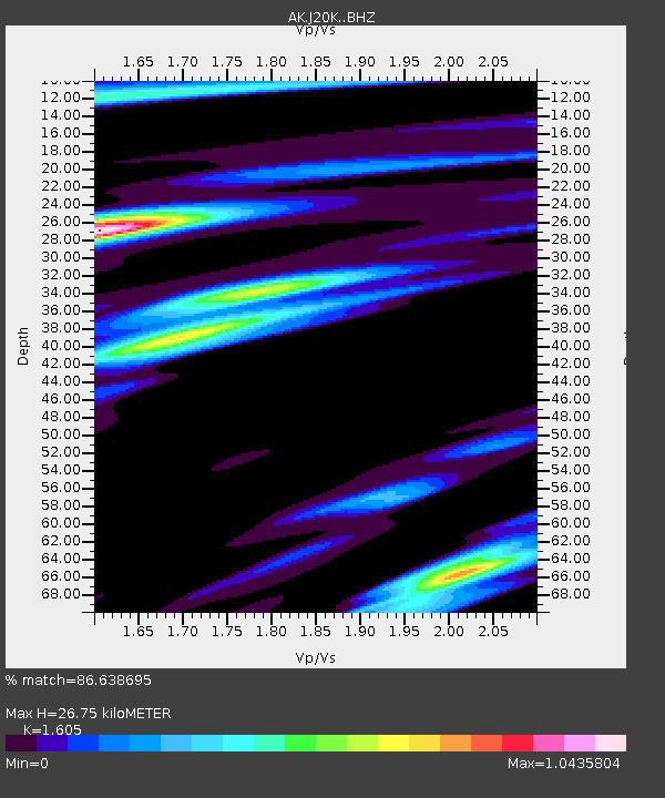
| Estimated Moho Depth: |
26.75 km |
| Estimated Crust Vp/Vs: |
1.61 |
| Assumed Crust Vp: |
6.566 km/s |
| Estimated Crust Vs: |
4.091 km/s |
| Estimated Crust Poisson's Ratio: |
0.18 |
|
| Radial Match: |
86.638695 % |
| Radial Bump: |
286 |
| Transverse Match: |
78.60826 % |
| Transverse Bump: |
395 |
| SOD ConfigId: |
31937991 |
| Insert Time: |
2023-10-10 01:44:40.966 +0000 |
| GWidth: |
2.5 |
| Max Bumps: |
400 |
| Tol: |
0.001 |
|

Signal To Noise
| Channel | StoN | STA | LTA |
| AK:J20K: :BHZ:20230926T01:51:15.800013Z | 27.64065 | 2.281726E-6 | 8.254965E-8 |
| AK:J20K: :BHN:20230926T01:51:15.800013Z | 3.2622018 | 3.284564E-7 | 1.0068549E-7 |
| AK:J20K: :BHE:20230926T01:51:15.800013Z | 5.3607802 | 8.060892E-7 | 1.503679E-7 |
| Arrivals |
| Ps | 2.5 SECOND |
| PpPs | 10 SECOND |
| PsPs/PpSs | 13 SECOND |


