You are here: Home > Network List > AV - Alaska Volcano Observatory Stations List
> Station SPNN North Nagishlamina, Mount Spurr, Alaska > Earthquake Result Viewer
SPNN North Nagishlamina, Mount Spurr, Alaska - Earthquake Result Viewer
| Earthquake location: |
Talaud Islands, Indonesia |
| Earthquake latitude/longitude: |
4.7/127.5 |
| Earthquake time(UTC): |
2023/09/26 (269) 01:39:44 GMT |
| Earthquake Depth: |
100 km |
| Earthquake Magnitude: |
5.9 mww |
| Earthquake Catalog/Contributor: |
NEIC PDE/us |
|
| Network: |
AV Alaska Volcano Observatory |
| Station: |
SPNN North Nagishlamina, Mount Spurr, Alaska |
| Lat/Lon: |
61.37 N/152.70 W |
| Elevation: |
1666 m |
|
| Distance: |
81.0 deg |
| Az: |
28.686 deg |
| Baz: |
263.299 deg |
| Ray Param: |
0.0476921 |
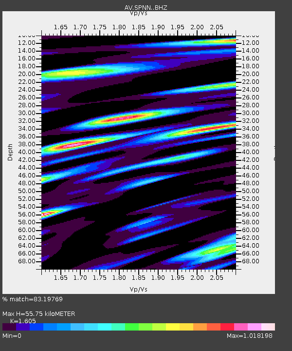
| Estimated Moho Depth: |
55.75 km |
| Estimated Crust Vp/Vs: |
1.61 |
| Assumed Crust Vp: |
6.566 km/s |
| Estimated Crust Vs: |
4.091 km/s |
| Estimated Crust Poisson's Ratio: |
0.18 |
|
| Radial Match: |
83.19769 % |
| Radial Bump: |
400 |
| Transverse Match: |
76.08499 % |
| Transverse Bump: |
400 |
| SOD ConfigId: |
31937991 |
| Insert Time: |
2023-10-10 01:50:58.202 +0000 |
| GWidth: |
2.5 |
| Max Bumps: |
400 |
| Tol: |
0.001 |
|

Signal To Noise
| Channel | StoN | STA | LTA |
| AV:SPNN: :BHZ:20230926T01:51:17.319972Z | 11.126454 | 2.1905455E-6 | 1.9687722E-7 |
| AV:SPNN: :BHN:20230926T01:51:17.319972Z | 2.368612 | 2.7688955E-7 | 1.1689949E-7 |
| AV:SPNN: :BHE:20230926T01:51:17.319972Z | 6.5336037 | 8.755796E-7 | 1.3401173E-7 |
| Arrivals |
| Ps | 5.3 SECOND |
| PpPs | 21 SECOND |
| PsPs/PpSs | 27 SECOND |


