You are here: Home > Network List > TA - USArray Transportable Network (new EarthScope stations) Stations List
> Station F23A Volborg, MT, USA > Earthquake Result Viewer
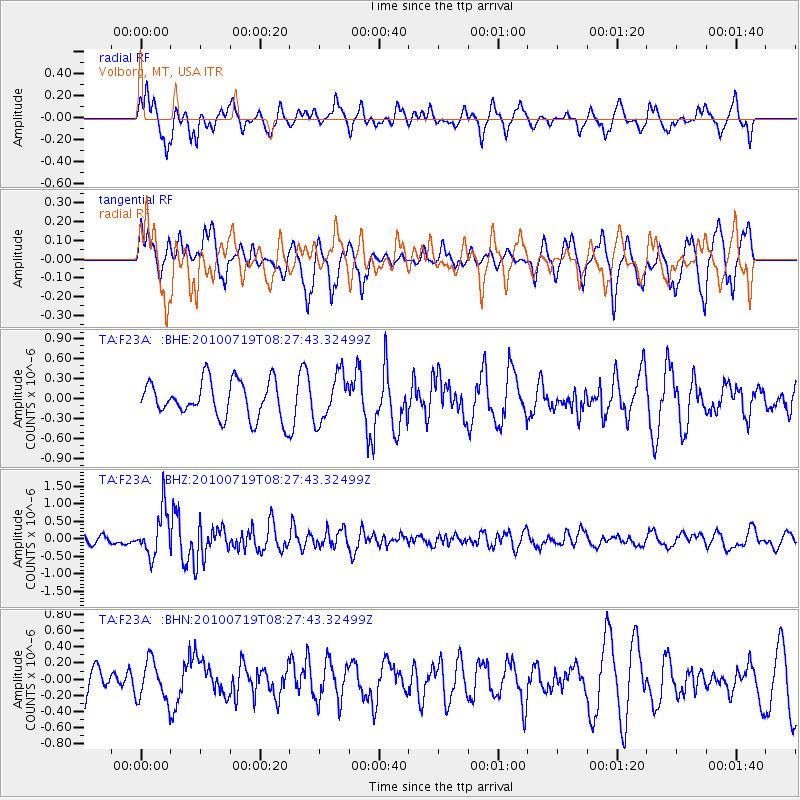
F23A Volborg, MT, USA - Earthquake Result Viewer
*The percent match for this event was below the threshold and hence no stack was calculated.
| Earthquake location: |
Fox Islands, Aleutian Islands |
| Earthquake latitude/longitude: |
52.7/-169.3 |
| Earthquake time(UTC): |
2010/07/19 (200) 08:20:30 GMT |
| Earthquake Depth: |
10 km |
| Earthquake Magnitude: |
5.6 MW, 5.2 MS, 5.4 MB, 5.1 ML |
| Earthquake Catalog/Contributor: |
WHDF/NEIC |
|
| Network: |
TA USArray Transportable Network (new EarthScope stations) |
| Station: |
F23A Volborg, MT, USA |
| Lat/Lon: |
45.72 N/105.41 W |
| Elevation: |
953 m |
|
| Distance: |
41.1 deg |
| Az: |
73.153 deg |
| Baz: |
303.668 deg |
| Ray Param: |
$rayparam |
*The percent match for this event was below the threshold and hence was not used in the summary stack. |
|
| Radial Match: |
63.13396 % |
| Radial Bump: |
399 |
| Transverse Match: |
64.08857 % |
| Transverse Bump: |
391 |
| SOD ConfigId: |
319893 |
| Insert Time: |
2011-01-05 08:09:50.243 +0000 |
| GWidth: |
2.5 |
| Max Bumps: |
400 |
| Tol: |
0.001 |
|
Signal To Noise
| Channel | StoN | STA | LTA |
| TA:F23A: :BHZ:20100719T08:27:43.32499Z | 3.683499 | 6.517701E-7 | 1.769432E-7 |
| TA:F23A: :BHN:20100719T08:27:43.32499Z | 0.9651244 | 2.4627033E-7 | 2.5516954E-7 |
| TA:F23A: :BHE:20100719T08:27:43.32499Z | 1.275798 | 3.5018655E-7 | 2.7448434E-7 |
| Arrivals |
| Ps | |
| PpPs | |
| PsPs/PpSs | |


