You are here: Home > Network List > TA - USArray Transportable Network (new EarthScope stations) Stations List
> Station L25A Engebretsen Ranch, Morrill, NE, USA > Earthquake Result Viewer
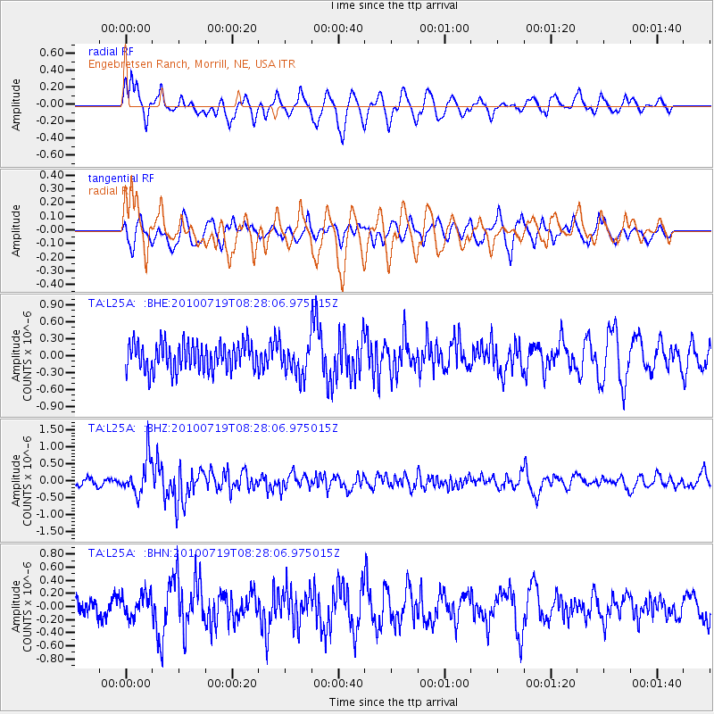
L25A Engebretsen Ranch, Morrill, NE, USA - Earthquake Result Viewer
*The percent match for this event was below the threshold and hence no stack was calculated.
| Earthquake location: |
Fox Islands, Aleutian Islands |
| Earthquake latitude/longitude: |
52.7/-169.3 |
| Earthquake time(UTC): |
2010/07/19 (200) 08:20:30 GMT |
| Earthquake Depth: |
10 km |
| Earthquake Magnitude: |
5.6 MW, 5.2 MS, 5.4 MB, 5.1 ML |
| Earthquake Catalog/Contributor: |
WHDF/NEIC |
|
| Network: |
TA USArray Transportable Network (new EarthScope stations) |
| Station: |
L25A Engebretsen Ranch, Morrill, NE, USA |
| Lat/Lon: |
42.15 N/103.97 W |
| Elevation: |
1379 m |
|
| Distance: |
44.0 deg |
| Az: |
76.557 deg |
| Baz: |
307.172 deg |
| Ray Param: |
$rayparam |
*The percent match for this event was below the threshold and hence was not used in the summary stack. |
|
| Radial Match: |
57.040504 % |
| Radial Bump: |
389 |
| Transverse Match: |
52.56137 % |
| Transverse Bump: |
400 |
| SOD ConfigId: |
319893 |
| Insert Time: |
2011-01-05 08:10:04.060 +0000 |
| GWidth: |
2.5 |
| Max Bumps: |
400 |
| Tol: |
0.001 |
|
Signal To Noise
| Channel | StoN | STA | LTA |
| TA:L25A: :BHZ:20100719T08:28:06.975015Z | 4.882411 | 5.4807305E-7 | 1.122546E-7 |
| TA:L25A: :BHN:20100719T08:28:06.975015Z | 1.2812709 | 1.7855507E-7 | 1.393578E-7 |
| TA:L25A: :BHE:20100719T08:28:06.975015Z | 1.1827083 | 2.873873E-7 | 2.4299086E-7 |
| Arrivals |
| Ps | |
| PpPs | |
| PsPs/PpSs | |


