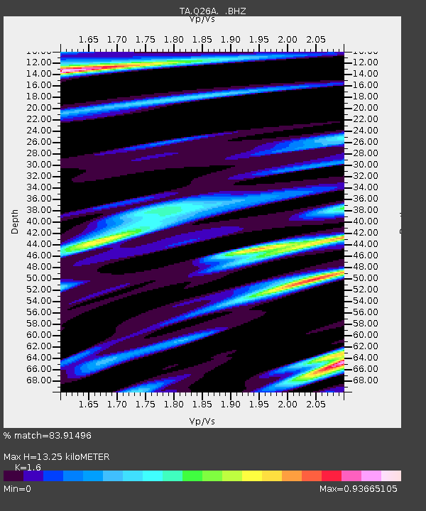
Q26A Hugo, CO, USA - Earthquake Result Viewer
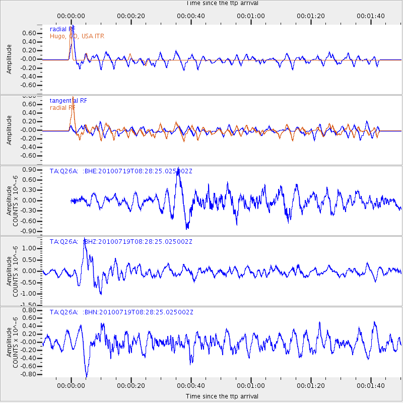
Earthquake location: Fox Islands, Aleutian Islands
Earthquake latitude/longitude: 52.7/-169.3
Earthquake time(UTC): 2010/07/19 (200) 08:20:30 GMT
Earthquake Depth: 10 km
Earthquake Magnitude: 5.6 MW, 5.2 MS, 5.4 MB, 5.1 ML
Earthquake Catalog/Contributor: WHDF/NEIC
Network: TA USArray Transportable Network (new EarthScope stations)
Station: Q26A Hugo, CO, USA
Lat/Lon: 38.92 N/103.52 W
Elevation: 1546 m
Distance: 46.3 deg
Az: 79.823 deg
Baz: 309.765 deg
Ray Param: 0.07073095
Estimated Moho Depth: 13.25 km
Estimated Crust Vp/Vs: 1.60
Assumed Crust Vp: 6.242 km/s
Estimated Crust Vs: 3.901 km/s
Estimated Crust Poisson's Ratio: 0.18
Radial Match: 83.91496 %
Radial Bump: 400
Transverse Match: 56.753376 %
Transverse Bump: 333
SOD ConfigId: 319893
Insert Time: 2011-01-05 08:10:54.430 +0000
GWidth: 2.5
Max Bumps: 400
Tol: 0.001

Signal To Noise

ChannelStoNSTALTA
TA:Q26A: :BHZ:20100719T08:28:25.025002Z6.6801395.424479E-78.120308E-8
TA:Q26A: :BHN:20100719T08:28:25.025002Z2.42506722.7469486E-71.1327309E-7
TA:Q26A: :BHE:20100719T08:28:25.025002Z2.17084482.7101746E-71.2484423E-7
Arrivals
Ps1.4 SECOND
PpPs5.2 SECOND
PsPs/PpSs6.5 SECOND