You are here: Home > Network List > TA - USArray Transportable Network (new EarthScope stations) Stations List
> Station S26A Kim, CO, USA > Earthquake Result Viewer
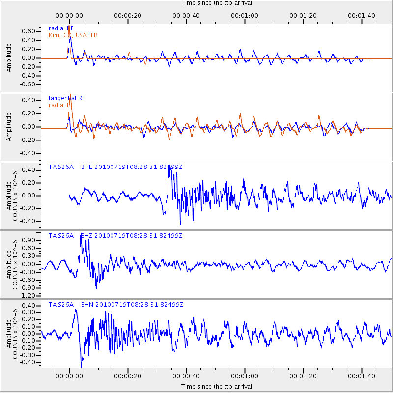
S26A Kim, CO, USA - Earthquake Result Viewer
*The percent match for this event was below the threshold and hence no stack was calculated.
| Earthquake location: |
Fox Islands, Aleutian Islands |
| Earthquake latitude/longitude: |
52.7/-169.3 |
| Earthquake time(UTC): |
2010/07/19 (200) 08:20:30 GMT |
| Earthquake Depth: |
10 km |
| Earthquake Magnitude: |
5.6 MW, 5.2 MS, 5.4 MB, 5.1 ML |
| Earthquake Catalog/Contributor: |
WHDF/NEIC |
|
| Network: |
TA USArray Transportable Network (new EarthScope stations) |
| Station: |
S26A Kim, CO, USA |
| Lat/Lon: |
37.62 N/103.47 W |
| Elevation: |
1394 m |
|
| Distance: |
47.2 deg |
| Az: |
81.152 deg |
| Baz: |
310.705 deg |
| Ray Param: |
$rayparam |
*The percent match for this event was below the threshold and hence was not used in the summary stack. |
|
| Radial Match: |
74.45089 % |
| Radial Bump: |
400 |
| Transverse Match: |
61.801697 % |
| Transverse Bump: |
400 |
| SOD ConfigId: |
319893 |
| Insert Time: |
2011-01-05 08:11:09.645 +0000 |
| GWidth: |
2.5 |
| Max Bumps: |
400 |
| Tol: |
0.001 |
|
Signal To Noise
| Channel | StoN | STA | LTA |
| TA:S26A: :BHZ:20100719T08:28:31.82499Z | 6.2715816 | 4.5010347E-7 | 7.176874E-8 |
| TA:S26A: :BHN:20100719T08:28:31.82499Z | 3.1446302 | 2.2193626E-7 | 7.057626E-8 |
| TA:S26A: :BHE:20100719T08:28:31.82499Z | 3.7244847 | 2.1384417E-7 | 5.741578E-8 |
| Arrivals |
| Ps | |
| PpPs | |
| PsPs/PpSs | |


