You are here: Home > Network List > TA - USArray Transportable Network (new EarthScope stations) Stations List
> Station M26A McRoberts Ranch, Bridgeport, NE, USA > Earthquake Result Viewer
M26A McRoberts Ranch, Bridgeport, NE, USA - Earthquake Result Viewer
| Earthquake location: |
Fox Islands, Aleutian Islands |
| Earthquake latitude/longitude: |
52.7/-169.3 |
| Earthquake time(UTC): |
2010/07/19 (200) 08:20:30 GMT |
| Earthquake Depth: |
10 km |
| Earthquake Magnitude: |
5.6 MW, 5.2 MS, 5.4 MB, 5.1 ML |
| Earthquake Catalog/Contributor: |
WHDF/NEIC |
|
| Network: |
TA USArray Transportable Network (new EarthScope stations) |
| Station: |
M26A McRoberts Ranch, Bridgeport, NE, USA |
| Lat/Lon: |
41.47 N/103.14 W |
| Elevation: |
1348 m |
|
| Distance: |
44.9 deg |
| Az: |
76.801 deg |
| Baz: |
307.893 deg |
| Ray Param: |
0.071613386 |
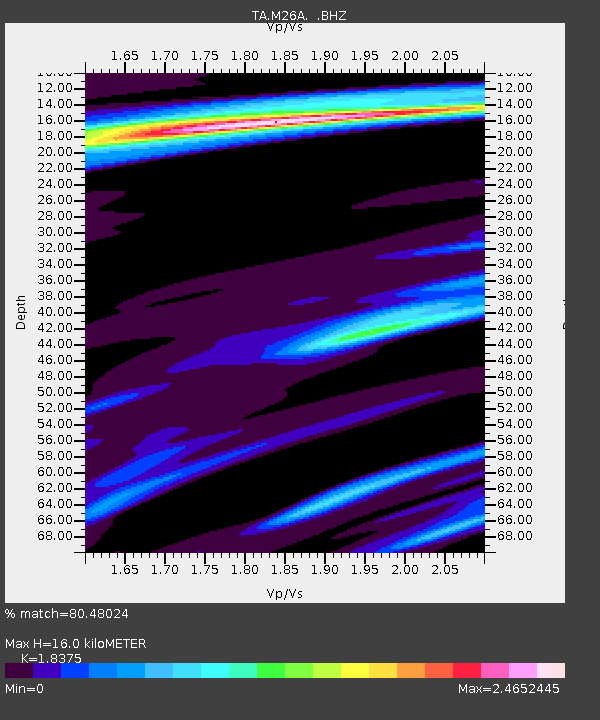
| Estimated Moho Depth: |
16.0 km |
| Estimated Crust Vp/Vs: |
1.84 |
| Assumed Crust Vp: |
6.483 km/s |
| Estimated Crust Vs: |
3.528 km/s |
| Estimated Crust Poisson's Ratio: |
0.29 |
|
| Radial Match: |
80.48024 % |
| Radial Bump: |
350 |
| Transverse Match: |
68.1007 % |
| Transverse Bump: |
396 |
| SOD ConfigId: |
319893 |
| Insert Time: |
2011-01-05 08:11:10.396 +0000 |
| GWidth: |
2.5 |
| Max Bumps: |
400 |
| Tol: |
0.001 |
|
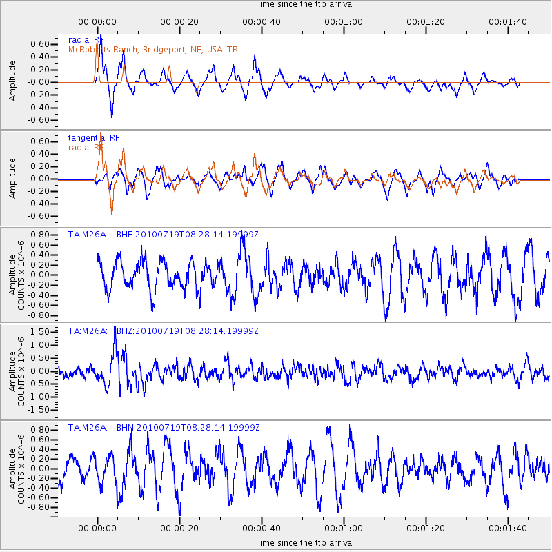
Signal To Noise
| Channel | StoN | STA | LTA |
| TA:M26A: :BHZ:20100719T08:28:14.19999Z | 5.0492344 | 6.3744875E-7 | 1.2624662E-7 |
| TA:M26A: :BHN:20100719T08:28:14.19999Z | 1.1996076 | 2.736403E-7 | 2.2810818E-7 |
| TA:M26A: :BHE:20100719T08:28:14.19999Z | 1.1877533 | 3.2502194E-7 | 2.736443E-7 |
| Arrivals |
| Ps | 2.2 SECOND |
| PpPs | 6.6 SECOND |
| PsPs/PpSs | 8.8 SECOND |


