You are here: Home > Network List > TA - USArray Transportable Network (new EarthScope stations) Stations List
> Station N26A Koester Ranch, Padroni, CO, USA > Earthquake Result Viewer
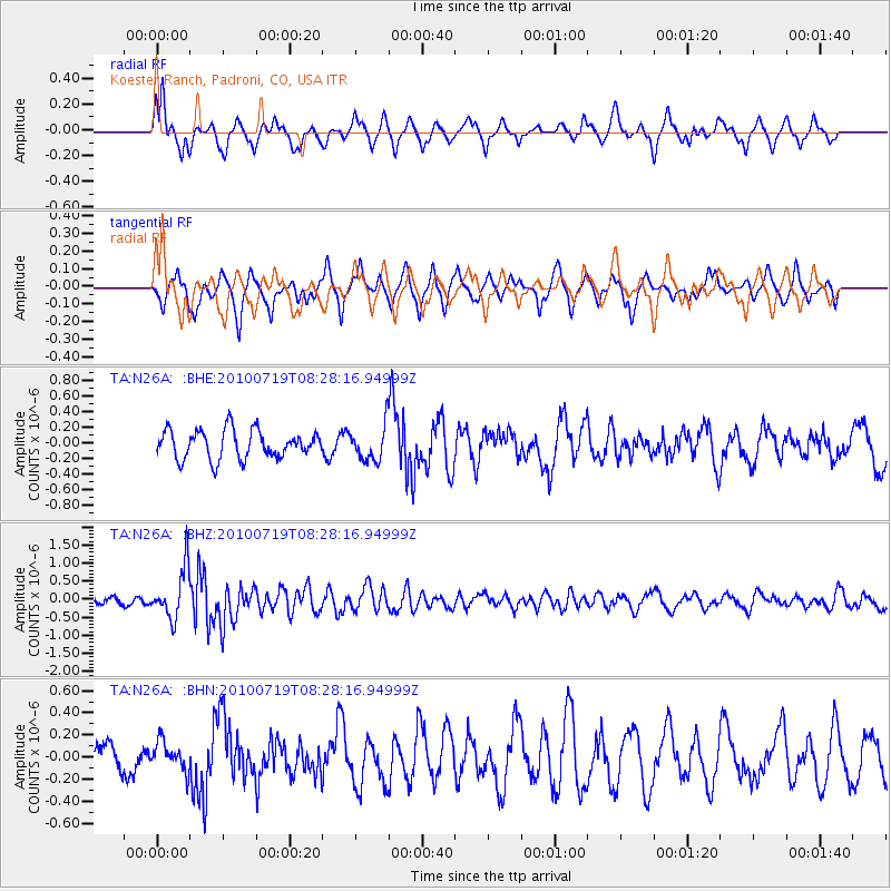
N26A Koester Ranch, Padroni, CO, USA - Earthquake Result Viewer
*The percent match for this event was below the threshold and hence no stack was calculated.
| Earthquake location: |
Fox Islands, Aleutian Islands |
| Earthquake latitude/longitude: |
52.7/-169.3 |
| Earthquake time(UTC): |
2010/07/19 (200) 08:20:30 GMT |
| Earthquake Depth: |
10 km |
| Earthquake Magnitude: |
5.6 MW, 5.2 MS, 5.4 MB, 5.1 ML |
| Earthquake Catalog/Contributor: |
WHDF/NEIC |
|
| Network: |
TA USArray Transportable Network (new EarthScope stations) |
| Station: |
N26A Koester Ranch, Padroni, CO, USA |
| Lat/Lon: |
40.83 N/103.22 W |
| Elevation: |
1284 m |
|
| Distance: |
45.3 deg |
| Az: |
77.56 deg |
| Baz: |
308.377 deg |
| Ray Param: |
$rayparam |
*The percent match for this event was below the threshold and hence was not used in the summary stack. |
|
| Radial Match: |
72.46119 % |
| Radial Bump: |
399 |
| Transverse Match: |
62.9011 % |
| Transverse Bump: |
361 |
| SOD ConfigId: |
319893 |
| Insert Time: |
2011-01-05 08:11:23.920 +0000 |
| GWidth: |
2.5 |
| Max Bumps: |
400 |
| Tol: |
0.001 |
|
Signal To Noise
| Channel | StoN | STA | LTA |
| TA:N26A: :BHZ:20100719T08:28:16.94999Z | 8.252148 | 6.9419065E-7 | 8.412242E-8 |
| TA:N26A: :BHN:20100719T08:28:16.94999Z | 0.7539066 | 1.3398267E-7 | 1.7771788E-7 |
| TA:N26A: :BHE:20100719T08:28:16.94999Z | 1.2532091 | 2.2596168E-7 | 1.8030646E-7 |
| Arrivals |
| Ps | |
| PpPs | |
| PsPs/PpSs | |


