You are here: Home > Network List > TA - USArray Transportable Network (new EarthScope stations) Stations List
> Station 128A Castleberry Farm, Seminole, TX, USA > Earthquake Result Viewer
128A Castleberry Farm, Seminole, TX, USA - Earthquake Result Viewer
| Earthquake location: |
Fox Islands, Aleutian Islands |
| Earthquake latitude/longitude: |
52.7/-169.3 |
| Earthquake time(UTC): |
2010/07/19 (200) 08:20:30 GMT |
| Earthquake Depth: |
10 km |
| Earthquake Magnitude: |
5.6 MW, 5.2 MS, 5.4 MB, 5.1 ML |
| Earthquake Catalog/Contributor: |
WHDF/NEIC |
|
| Network: |
TA USArray Transportable Network (new EarthScope stations) |
| Station: |
128A Castleberry Farm, Seminole, TX, USA |
| Lat/Lon: |
32.62 N/102.49 W |
| Elevation: |
966 m |
|
| Distance: |
51.1 deg |
| Az: |
85.306 deg |
| Baz: |
313.99 deg |
| Ray Param: |
0.06760857 |
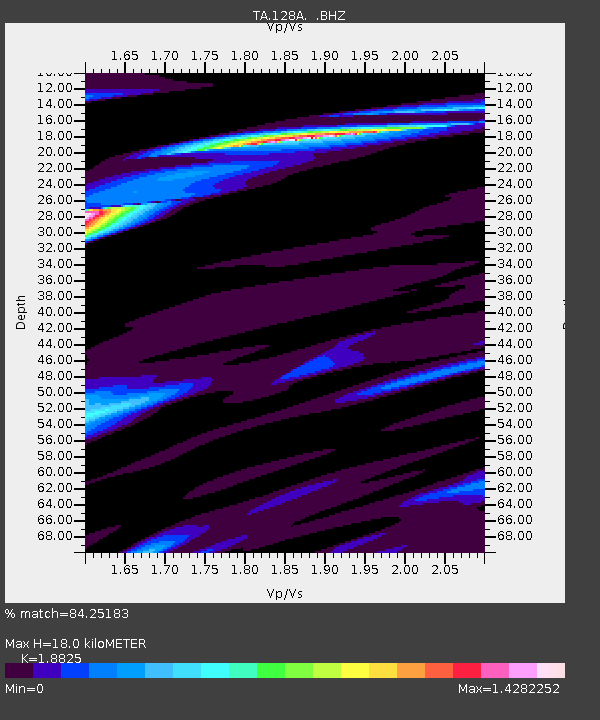
| Estimated Moho Depth: |
18.0 km |
| Estimated Crust Vp/Vs: |
1.88 |
| Assumed Crust Vp: |
6.129 km/s |
| Estimated Crust Vs: |
3.256 km/s |
| Estimated Crust Poisson's Ratio: |
0.30 |
|
| Radial Match: |
84.25183 % |
| Radial Bump: |
400 |
| Transverse Match: |
58.071487 % |
| Transverse Bump: |
400 |
| SOD ConfigId: |
319893 |
| Insert Time: |
2011-01-05 08:12:56.194 +0000 |
| GWidth: |
2.5 |
| Max Bumps: |
400 |
| Tol: |
0.001 |
|

Signal To Noise
| Channel | StoN | STA | LTA |
| TA:128A: :BHZ:20100719T08:29:02.100015Z | 9.79111 | 7.9412314E-7 | 8.1106556E-8 |
| TA:128A: :BHN:20100719T08:29:02.100015Z | 4.691036 | 4.2058088E-7 | 8.965628E-8 |
| TA:128A: :BHE:20100719T08:29:02.100015Z | 3.5725932 | 3.3087528E-7 | 9.261488E-8 |
| Arrivals |
| Ps | 2.7 SECOND |
| PpPs | 8.1 SECOND |
| PsPs/PpSs | 11 SECOND |


