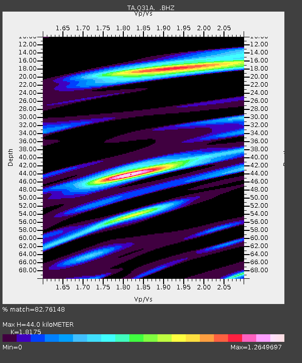
Q31A Ellis, KS, USA - Earthquake Result Viewer

Earthquake location: Fox Islands, Aleutian Islands
Earthquake latitude/longitude: 52.7/-169.3
Earthquake time(UTC): 2010/07/19 (200) 08:20:30 GMT
Earthquake Depth: 10 km
Earthquake Magnitude: 5.6 MW, 5.2 MS, 5.4 MB, 5.1 ML
Earthquake Catalog/Contributor: WHDF/NEIC
Network: TA USArray Transportable Network (new EarthScope stations)
Station: Q31A Ellis, KS, USA
Lat/Lon: 39.00 N/99.39 W
Elevation: 680 m
Distance: 48.7 deg
Az: 76.931 deg
Baz: 310.394 deg
Ray Param: 0.0691827
Estimated Moho Depth: 44.0 km
Estimated Crust Vp/Vs: 1.82
Assumed Crust Vp: 6.483 km/s
Estimated Crust Vs: 3.567 km/s
Estimated Crust Poisson's Ratio: 0.28
Radial Match: 82.76148 %
Radial Bump: 400
Transverse Match: 65.70275 %
Transverse Bump: 400
SOD ConfigId: 319893
Insert Time: 2011-01-05 08:18:35.665 +0000
GWidth: 2.5
Max Bumps: 400
Tol: 0.001

Signal To Noise

ChannelStoNSTALTA
TA:Q31A: :BHZ:20100719T08:28:43.725015Z11.3930297.070145E-76.205676E-8
TA:Q31A: :BHN:20100719T08:28:43.725015Z3.62575583.3777437E-79.3159706E-8
TA:Q31A: :BHE:20100719T08:28:43.725015Z3.163792.4924867E-77.878167E-8
Arrivals
Ps5.9 SECOND
PpPs18 SECOND
PsPs/PpSs24 SECOND