You are here: Home > Network List > TA - USArray Transportable Network (new EarthScope stations) Stations List
> Station B25A Knox Farm, Ray, ND, USA > Earthquake Result Viewer
B25A Knox Farm, Ray, ND, USA - Earthquake Result Viewer
| Earthquake location: |
Fox Islands, Aleutian Islands |
| Earthquake latitude/longitude: |
52.7/-169.3 |
| Earthquake time(UTC): |
2010/07/19 (200) 08:20:30 GMT |
| Earthquake Depth: |
10 km |
| Earthquake Magnitude: |
5.6 MW, 5.2 MS, 5.4 MB, 5.1 ML |
| Earthquake Catalog/Contributor: |
WHDF/NEIC |
|
| Network: |
TA USArray Transportable Network (new EarthScope stations) |
| Station: |
B25A Knox Farm, Ray, ND, USA |
| Lat/Lon: |
48.27 N/103.16 W |
| Elevation: |
705 m |
|
| Distance: |
41.0 deg |
| Az: |
68.621 deg |
| Baz: |
301.887 deg |
| Ray Param: |
0.07405398 |
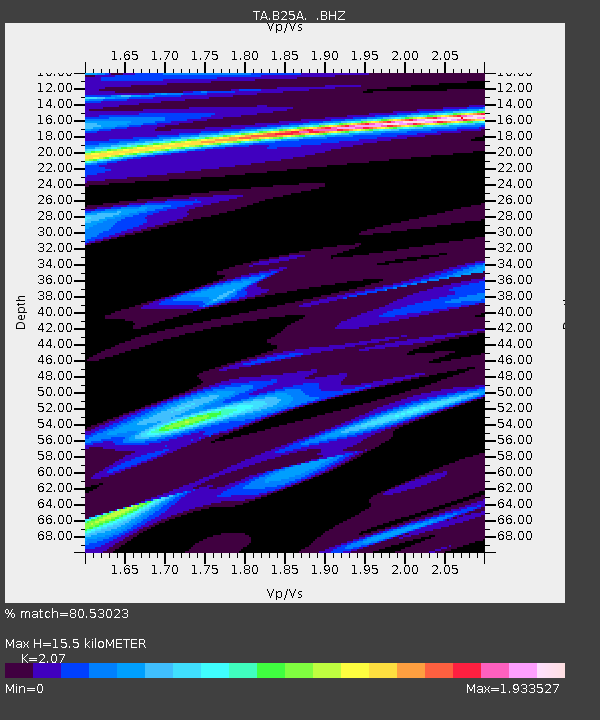
| Estimated Moho Depth: |
15.5 km |
| Estimated Crust Vp/Vs: |
2.07 |
| Assumed Crust Vp: |
6.438 km/s |
| Estimated Crust Vs: |
3.11 km/s |
| Estimated Crust Poisson's Ratio: |
0.35 |
|
| Radial Match: |
80.53023 % |
| Radial Bump: |
400 |
| Transverse Match: |
60.54617 % |
| Transverse Bump: |
376 |
| SOD ConfigId: |
319893 |
| Insert Time: |
2011-01-05 08:21:40.140 +0000 |
| GWidth: |
2.5 |
| Max Bumps: |
400 |
| Tol: |
0.001 |
|

Signal To Noise
| Channel | StoN | STA | LTA |
| TA:B25A: :BHZ:20100719T08:27:42.57499Z | 3.1801221 | 5.6789685E-7 | 1.7857705E-7 |
| TA:B25A: :BHN:20100719T08:27:42.57499Z | 1.3625886 | 4.5793632E-7 | 3.360782E-7 |
| TA:B25A: :BHE:20100719T08:27:42.57499Z | 1.884283 | 5.911141E-7 | 3.1370772E-7 |
| Arrivals |
| Ps | 2.7 SECOND |
| PpPs | 7.0 SECOND |
| PsPs/PpSs | 9.7 SECOND |


