You are here: Home > Network List > TA - USArray Transportable Network (new EarthScope stations) Stations List
> Station E29A Napoleon, ND, USA > Earthquake Result Viewer
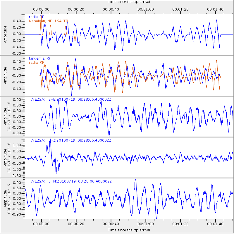
E29A Napoleon, ND, USA - Earthquake Result Viewer
*The percent match for this event was below the threshold and hence no stack was calculated.
| Earthquake location: |
Fox Islands, Aleutian Islands |
| Earthquake latitude/longitude: |
52.7/-169.3 |
| Earthquake time(UTC): |
2010/07/19 (200) 08:20:30 GMT |
| Earthquake Depth: |
10 km |
| Earthquake Magnitude: |
5.6 MW, 5.2 MS, 5.4 MB, 5.1 ML |
| Earthquake Catalog/Contributor: |
WHDF/NEIC |
|
| Network: |
TA USArray Transportable Network (new EarthScope stations) |
| Station: |
E29A Napoleon, ND, USA |
| Lat/Lon: |
46.57 N/99.64 W |
| Elevation: |
628 m |
|
| Distance: |
44.0 deg |
| Az: |
68.791 deg |
| Baz: |
304.596 deg |
| Ray Param: |
$rayparam |
*The percent match for this event was below the threshold and hence was not used in the summary stack. |
|
| Radial Match: |
53.657555 % |
| Radial Bump: |
400 |
| Transverse Match: |
64.46679 % |
| Transverse Bump: |
400 |
| SOD ConfigId: |
319893 |
| Insert Time: |
2011-01-05 08:22:42.927 +0000 |
| GWidth: |
2.5 |
| Max Bumps: |
400 |
| Tol: |
0.001 |
|
Signal To Noise
| Channel | StoN | STA | LTA |
| TA:E29A: :BHZ:20100719T08:28:06.400002Z | 6.9198947 | 5.2881796E-7 | 7.6419944E-8 |
| TA:E29A: :BHN:20100719T08:28:06.400002Z | 1.0056175 | 3.639098E-7 | 3.6187694E-7 |
| TA:E29A: :BHE:20100719T08:28:06.400002Z | 1.0271114 | 4.3852927E-7 | 4.2695396E-7 |
| Arrivals |
| Ps | |
| PpPs | |
| PsPs/PpSs | |


