You are here: Home > Network List > CN - Canadian National Seismograph Network Stations List
> Station INK INUVIK, NT > Earthquake Result Viewer
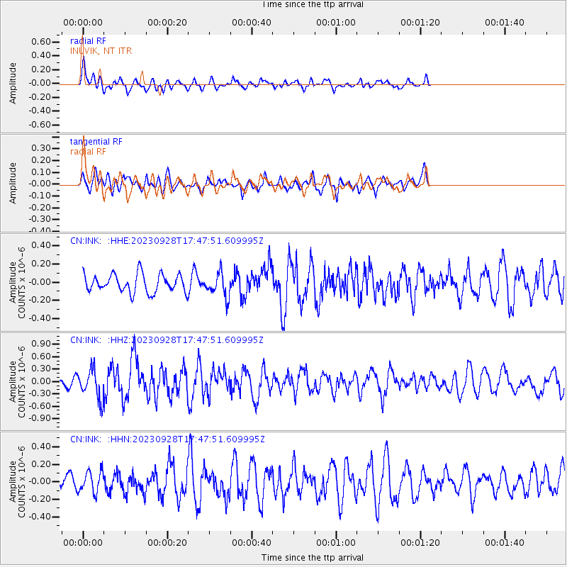
INK INUVIK, NT - Earthquake Result Viewer
*The percent match for this event was below the threshold and hence no stack was calculated.
| Earthquake location: |
Kuril Islands |
| Earthquake latitude/longitude: |
44.3/148.6 |
| Earthquake time(UTC): |
2023/09/28 (271) 17:40:04 GMT |
| Earthquake Depth: |
15 km |
| Earthquake Magnitude: |
5.8 mww |
| Earthquake Catalog/Contributor: |
NEIC PDE/us |
|
| Network: |
CN Canadian National Seismograph Network |
| Station: |
INK INUVIK, NT |
| Lat/Lon: |
68.31 N/133.53 W |
| Elevation: |
44 m |
|
| Distance: |
45.4 deg |
| Az: |
30.679 deg |
| Baz: |
279.538 deg |
| Ray Param: |
$rayparam |
*The percent match for this event was below the threshold and hence was not used in the summary stack. |
|
| Radial Match: |
63.8481 % |
| Radial Bump: |
400 |
| Transverse Match: |
56.67293 % |
| Transverse Bump: |
400 |
| SOD ConfigId: |
31937991 |
| Insert Time: |
2023-10-12 17:51:42.023 +0000 |
| GWidth: |
2.5 |
| Max Bumps: |
400 |
| Tol: |
0.001 |
|
Signal To Noise
| Channel | StoN | STA | LTA |
| CN:INK: :HHZ:20230928T17:47:51.609995Z | 2.2762592 | 3.6645534E-7 | 1.6099017E-7 |
| CN:INK: :HHN:20230928T17:47:51.609995Z | 1.584931 | 1.2010557E-7 | 7.577968E-8 |
| CN:INK: :HHE:20230928T17:47:51.609995Z | 1.341583 | 1.3308627E-7 | 9.9200925E-8 |
| Arrivals |
| Ps | |
| PpPs | |
| PsPs/PpSs | |


