You are here: Home > Network List > GM - US Geological Survey Networks Stations List
> Station IWM01 Jericho 2M Well Monitoring Station > Earthquake Result Viewer
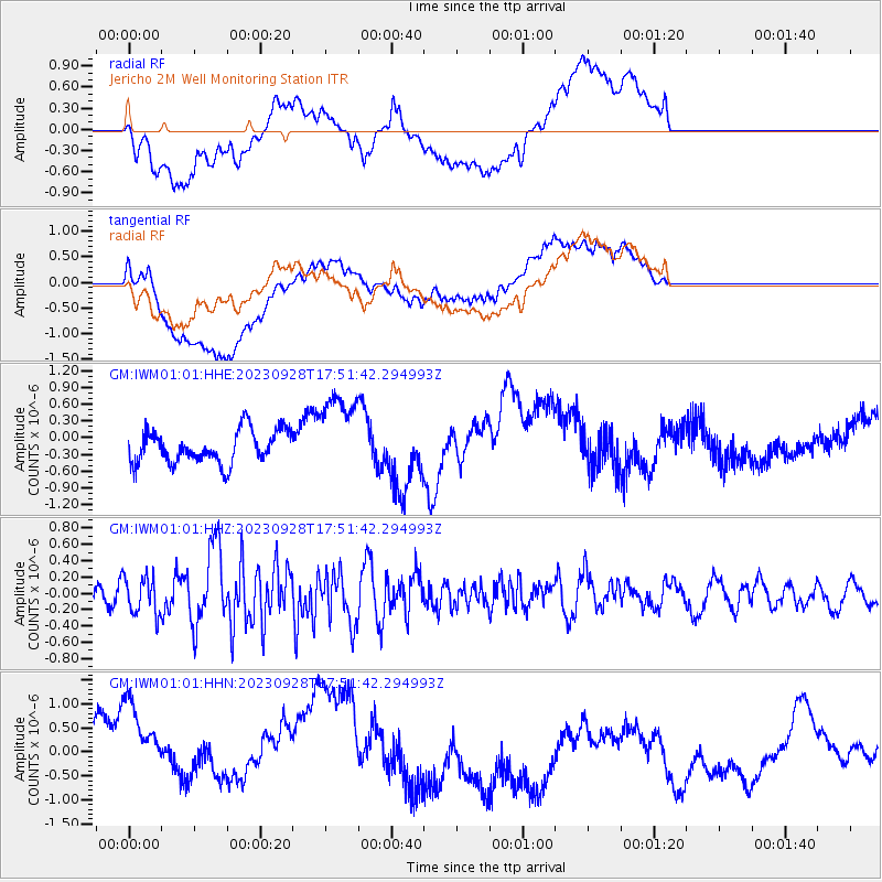
IWM01 Jericho 2M Well Monitoring Station - Earthquake Result Viewer
*The percent match for this event was below the threshold and hence no stack was calculated.
| Earthquake location: |
Kuril Islands |
| Earthquake latitude/longitude: |
44.3/148.6 |
| Earthquake time(UTC): |
2023/09/28 (271) 17:40:04 GMT |
| Earthquake Depth: |
15 km |
| Earthquake Magnitude: |
5.8 mww |
| Earthquake Catalog/Contributor: |
NEIC PDE/us |
|
| Network: |
GM US Geological Survey Networks |
| Station: |
IWM01 Jericho 2M Well Monitoring Station |
| Lat/Lon: |
36.73 N/96.53 W |
| Elevation: |
328 m |
|
| Distance: |
80.1 deg |
| Az: |
47.74 deg |
| Baz: |
318.55 deg |
| Ray Param: |
$rayparam |
*The percent match for this event was below the threshold and hence was not used in the summary stack. |
|
| Radial Match: |
52.50563 % |
| Radial Bump: |
400 |
| Transverse Match: |
44.914078 % |
| Transverse Bump: |
400 |
| SOD ConfigId: |
31937991 |
| Insert Time: |
2023-10-12 17:53:48.950 +0000 |
| GWidth: |
2.5 |
| Max Bumps: |
400 |
| Tol: |
0.001 |
|
Signal To Noise
| Channel | StoN | STA | LTA |
| GM:IWM01:01:HHZ:20230928T17:51:42.294993Z | 0.9442384 | 2.3372552E-7 | 2.4752805E-7 |
| GM:IWM01:01:HHN:20230928T17:51:42.294993Z | 1.6689993 | 1.5554099E-6 | 9.3194166E-7 |
| GM:IWM01:01:HHE:20230928T17:51:42.294993Z | 2.5667553 | 7.4681725E-7 | 2.909577E-7 |
| Arrivals |
| Ps | |
| PpPs | |
| PsPs/PpSs | |


