You are here: Home > Network List > IW - Intermountain West Stations List
> Station MOOW Moose Ponds, Wyoming, USA > Earthquake Result Viewer
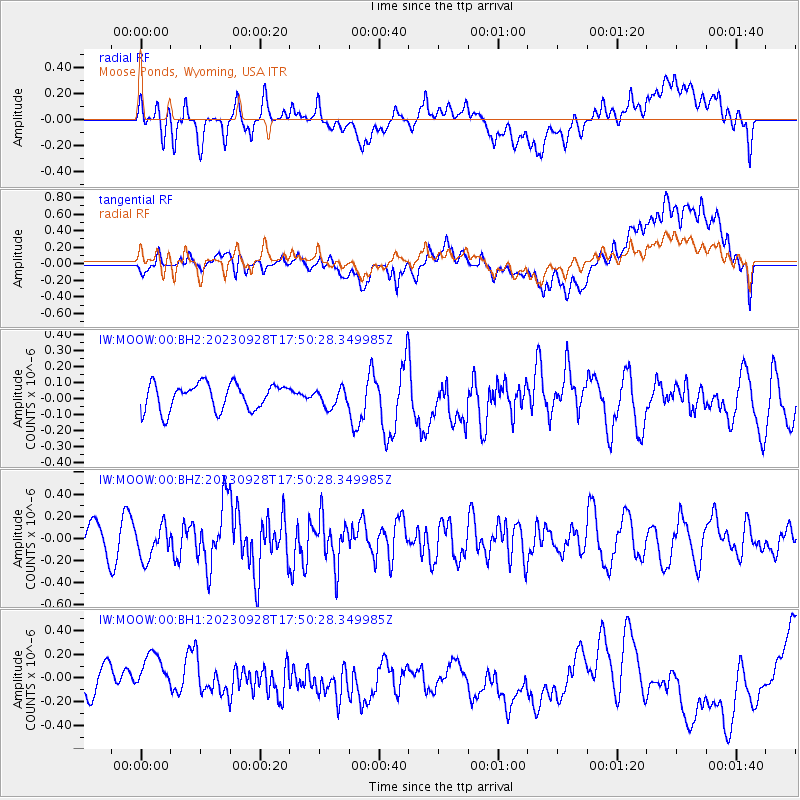
MOOW Moose Ponds, Wyoming, USA - Earthquake Result Viewer
*The percent match for this event was below the threshold and hence no stack was calculated.
| Earthquake location: |
Kuril Islands |
| Earthquake latitude/longitude: |
44.3/148.6 |
| Earthquake time(UTC): |
2023/09/28 (271) 17:40:04 GMT |
| Earthquake Depth: |
15 km |
| Earthquake Magnitude: |
5.8 mww |
| Earthquake Catalog/Contributor: |
NEIC PDE/us |
|
| Network: |
IW Intermountain West |
| Station: |
MOOW Moose Ponds, Wyoming, USA |
| Lat/Lon: |
43.75 N/110.74 W |
| Elevation: |
2128 m |
|
| Distance: |
67.5 deg |
| Az: |
50.458 deg |
| Baz: |
310.123 deg |
| Ray Param: |
$rayparam |
*The percent match for this event was below the threshold and hence was not used in the summary stack. |
|
| Radial Match: |
47.566574 % |
| Radial Bump: |
400 |
| Transverse Match: |
43.3304 % |
| Transverse Bump: |
400 |
| SOD ConfigId: |
31937991 |
| Insert Time: |
2023-10-12 17:56:09.378 +0000 |
| GWidth: |
2.5 |
| Max Bumps: |
400 |
| Tol: |
0.001 |
|
Signal To Noise
| Channel | StoN | STA | LTA |
| IW:MOOW:00:BHZ:20230928T17:50:28.349985Z | 1.3401037 | 1.4805411E-7 | 1.1047959E-7 |
| IW:MOOW:00:BH1:20230928T17:50:28.349985Z | 0.4372672 | 1.0151844E-7 | 2.3216568E-7 |
| IW:MOOW:00:BH2:20230928T17:50:28.349985Z | 0.7020357 | 5.7152768E-8 | 8.141006E-8 |
| Arrivals |
| Ps | |
| PpPs | |
| PsPs/PpSs | |


