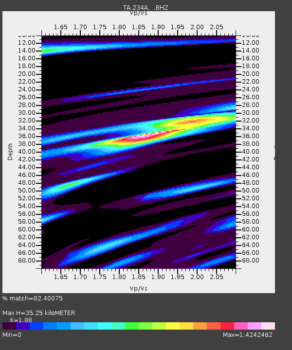
234A Clairette, TX, USA - Earthquake Result Viewer

Earthquake location: Fox Islands, Aleutian Islands
Earthquake latitude/longitude: 52.7/-169.3
Earthquake time(UTC): 2010/07/19 (200) 08:20:30 GMT
Earthquake Depth: 10 km
Earthquake Magnitude: 5.6 MW, 5.2 MS, 5.4 MB, 5.1 ML
Earthquake Catalog/Contributor: WHDF/NEIC
Network: TA USArray Transportable Network (new EarthScope stations)
Station: 234A Clairette, TX, USA
Lat/Lon: 32.00 N/98.14 W
Elevation: 358 m
Distance: 54.2 deg
Az: 82.623 deg
Baz: 314.676 deg
Ray Param: 0.06560215
Estimated Moho Depth: 35.25 km
Estimated Crust Vp/Vs: 1.88
Assumed Crust Vp: 6.426 km/s
Estimated Crust Vs: 3.418 km/s
Estimated Crust Poisson's Ratio: 0.30
Radial Match: 82.40075 %
Radial Bump: 400
Transverse Match: 65.78336 %
Transverse Bump: 400
SOD ConfigId: 319893
Insert Time: 2011-01-05 08:28:26.326 +0000
GWidth: 2.5
Max Bumps: 400
Tol: 0.001

Signal To Noise

ChannelStoNSTALTA
TA:234A: :BHZ:20100719T08:29:24.725015Z12.2275116.736373E-75.5091938E-8
TA:234A: :BHN:20100719T08:29:24.725015Z4.83324343.0628922E-76.337136E-8
TA:234A: :BHE:20100719T08:29:24.725015Z4.72017053.0030338E-76.36213E-8
Arrivals
Ps5.1 SECOND
PpPs15 SECOND
PsPs/PpSs20 SECOND