You are here: Home > Network List > TA - USArray Transportable Network (new EarthScope stations) Stations List
> Station Y37A Hugo, OK, USA > Earthquake Result Viewer
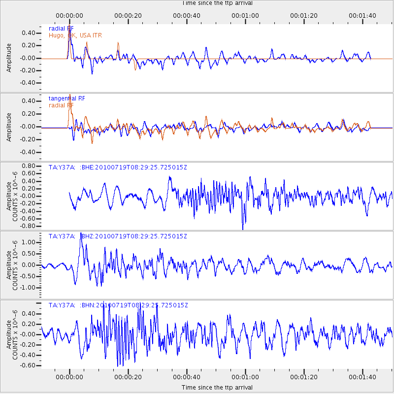
Y37A Hugo, OK, USA - Earthquake Result Viewer
*The percent match for this event was below the threshold and hence no stack was calculated.
| Earthquake location: |
Fox Islands, Aleutian Islands |
| Earthquake latitude/longitude: |
52.7/-169.3 |
| Earthquake time(UTC): |
2010/07/19 (200) 08:20:30 GMT |
| Earthquake Depth: |
10 km |
| Earthquake Magnitude: |
5.6 MW, 5.2 MS, 5.4 MB, 5.1 ML |
| Earthquake Catalog/Contributor: |
WHDF/NEIC |
|
| Network: |
TA USArray Transportable Network (new EarthScope stations) |
| Station: |
Y37A Hugo, OK, USA |
| Lat/Lon: |
33.98 N/95.62 W |
| Elevation: |
165 m |
|
| Distance: |
54.3 deg |
| Az: |
79.067 deg |
| Baz: |
313.963 deg |
| Ray Param: |
$rayparam |
*The percent match for this event was below the threshold and hence was not used in the summary stack. |
|
| Radial Match: |
65.91757 % |
| Radial Bump: |
400 |
| Transverse Match: |
55.09351 % |
| Transverse Bump: |
400 |
| SOD ConfigId: |
319893 |
| Insert Time: |
2011-01-05 08:33:12.844 +0000 |
| GWidth: |
2.5 |
| Max Bumps: |
400 |
| Tol: |
0.001 |
|
Signal To Noise
| Channel | StoN | STA | LTA |
| TA:Y37A: :BHZ:20100719T08:29:25.725015Z | 7.0778484 | 6.070106E-7 | 8.5762025E-8 |
| TA:Y37A: :BHN:20100719T08:29:25.725015Z | 2.492833 | 2.1810581E-7 | 8.749315E-8 |
| TA:Y37A: :BHE:20100719T08:29:25.725015Z | 1.6943284 | 2.5873283E-7 | 1.5270524E-7 |
| Arrivals |
| Ps | |
| PpPs | |
| PsPs/PpSs | |


