You are here: Home > Network List > CN - Canadian National Seismograph Network Stations List
> Station INK INUVIK, NT > Earthquake Result Viewer
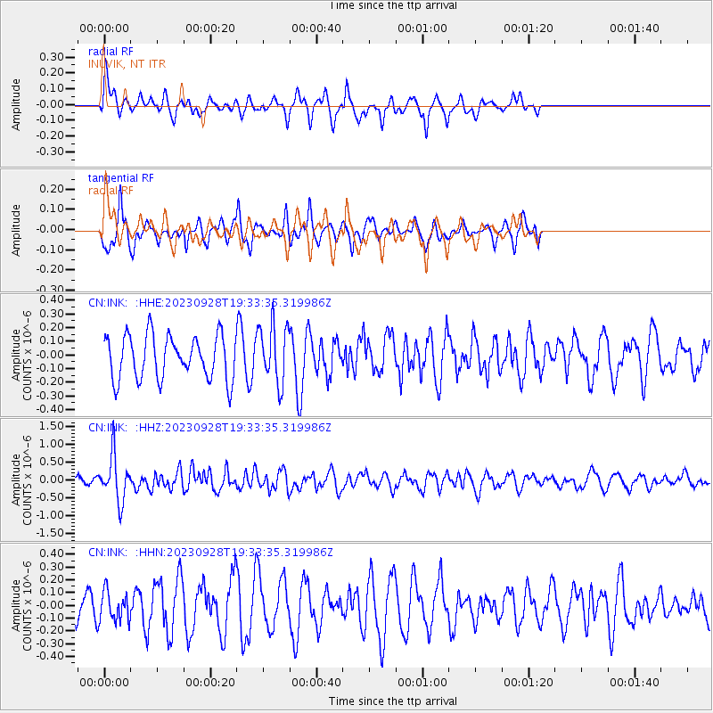
INK INUVIK, NT - Earthquake Result Viewer
*The percent match for this event was below the threshold and hence no stack was calculated.
| Earthquake location: |
New Britain Region, P.N.G. |
| Earthquake latitude/longitude: |
-5.3/152.8 |
| Earthquake time(UTC): |
2023/09/28 (271) 19:21:17 GMT |
| Earthquake Depth: |
49 km |
| Earthquake Magnitude: |
5.7 Mww |
| Earthquake Catalog/Contributor: |
NEIC PDE/us |
|
| Network: |
CN Canadian National Seismograph Network |
| Station: |
INK INUVIK, NT |
| Lat/Lon: |
68.31 N/133.53 W |
| Elevation: |
44 m |
|
| Distance: |
88.9 deg |
| Az: |
20.913 deg |
| Baz: |
252.958 deg |
| Ray Param: |
$rayparam |
*The percent match for this event was below the threshold and hence was not used in the summary stack. |
|
| Radial Match: |
65.059555 % |
| Radial Bump: |
400 |
| Transverse Match: |
50.906048 % |
| Transverse Bump: |
324 |
| SOD ConfigId: |
31937991 |
| Insert Time: |
2023-10-12 19:34:52.205 +0000 |
| GWidth: |
2.5 |
| Max Bumps: |
400 |
| Tol: |
0.001 |
|
Signal To Noise
| Channel | StoN | STA | LTA |
| CN:INK: :HHZ:20230928T19:33:35.319986Z | 2.7222505 | 6.357235E-7 | 2.3352867E-7 |
| CN:INK: :HHN:20230928T19:33:35.319986Z | 0.65534776 | 1.1244357E-7 | 1.7157848E-7 |
| CN:INK: :HHE:20230928T19:33:35.319986Z | 1.3473765 | 2.1491064E-7 | 1.5950305E-7 |
| Arrivals |
| Ps | |
| PpPs | |
| PsPs/PpSs | |


