You are here: Home > Network List > US - United States National Seismic Network Stations List
> Station TPNV Topopah Spring, Nevada, USA > Earthquake Result Viewer
TPNV Topopah Spring, Nevada, USA - Earthquake Result Viewer

| Earthquake location: |
New Ireland Region, P.N.G. |
| Earthquake latitude/longitude: |
-4.5/153.7 |
| Earthquake time(UTC): |
2023/10/03 (276) 01:56:17 GMT |
| Earthquake Depth: |
86 km |
| Earthquake Magnitude: |
5.7 mww |
| Earthquake Catalog/Contributor: |
NEIC PDE/us |
|
| Network: |
US United States National Seismic Network |
| Station: |
TPNV Topopah Spring, Nevada, USA |
| Lat/Lon: |
36.95 N/116.25 W |
| Elevation: |
1600 m |
|
| Distance: |
92.7 deg |
| Az: |
53.323 deg |
| Baz: |
266.437 deg |
| Ray Param: |
0.04136359 |
| Estimated Moho Depth: |
13.5 km |
| Estimated Crust Vp/Vs: |
2.10 |
| Assumed Crust Vp: |
6.279 km/s |
| Estimated Crust Vs: |
2.993 km/s |
| Estimated Crust Poisson's Ratio: |
0.35 |
|
| Radial Match: |
91.09335 % |
| Radial Bump: |
321 |
| Transverse Match: |
95.38315 % |
| Transverse Bump: |
291 |
| SOD ConfigId: |
31937991 |
| Insert Time: |
2023-10-17 02:12:09.757 +0000 |
| GWidth: |
2.5 |
| Max Bumps: |
400 |
| Tol: |
0.001 |
|
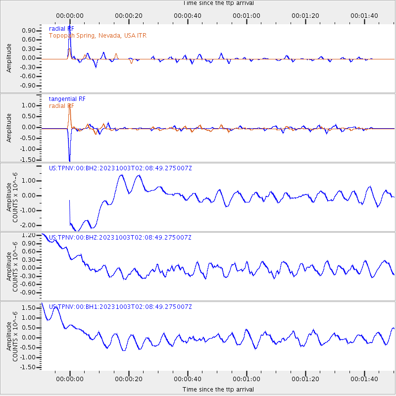
Signal To Noise
| Channel | StoN | STA | LTA |
| US:TPNV:00:BHZ:20231003T02:08:49.275007Z | 0.71070284 | 1.1719139E-6 | 1.6489507E-6 |
| US:TPNV:00:BH1:20231003T02:08:49.275007Z | 0.71670765 | 1.4296178E-6 | 1.9947015E-6 |
| US:TPNV:00:BH2:20231003T02:08:49.275007Z | 0.7027391 | 9.3023147E-7 | 1.3237224E-6 |
| Arrivals |
| Ps | 2.4 SECOND |
| PpPs | 6.6 SECOND |
| PsPs/PpSs | 9.0 SECOND |


