You are here: Home > Network List > AK - Alaska Regional Network Stations List
> Station H23K Yukon River, AK, USA > Earthquake Result Viewer
H23K Yukon River, AK, USA - Earthquake Result Viewer
| Earthquake location: |
Southeast Of Honshu, Japan |
| Earthquake latitude/longitude: |
29.9/140.0 |
| Earthquake time(UTC): |
2023/10/03 (276) 11:38:04 GMT |
| Earthquake Depth: |
12 km |
| Earthquake Magnitude: |
6.1 Mww |
| Earthquake Catalog/Contributor: |
NEIC PDE/us |
|
| Network: |
AK Alaska Regional Network |
| Station: |
H23K Yukon River, AK, USA |
| Lat/Lon: |
65.83 N/149.54 W |
| Elevation: |
617 m |
|
| Distance: |
55.1 deg |
| Az: |
28.23 deg |
| Baz: |
265.809 deg |
| Ray Param: |
0.064983435 |
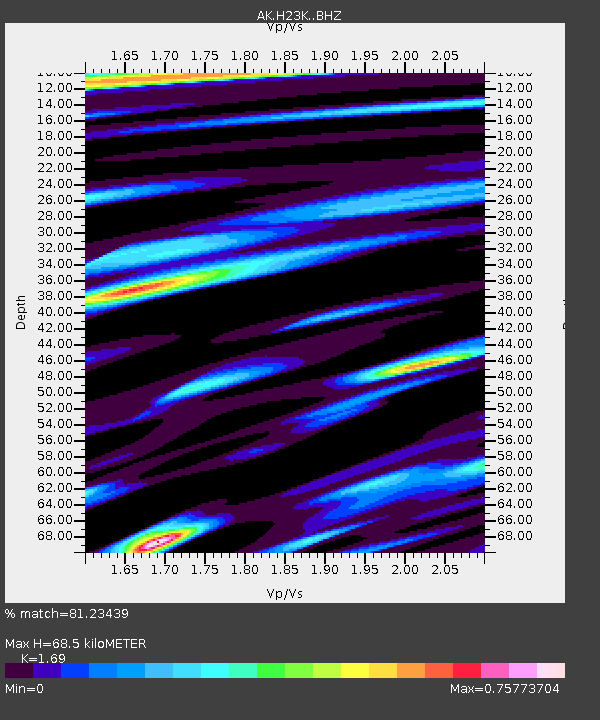
| Estimated Moho Depth: |
68.5 km |
| Estimated Crust Vp/Vs: |
1.69 |
| Assumed Crust Vp: |
6.566 km/s |
| Estimated Crust Vs: |
3.885 km/s |
| Estimated Crust Poisson's Ratio: |
0.23 |
|
| Radial Match: |
81.23439 % |
| Radial Bump: |
400 |
| Transverse Match: |
75.98449 % |
| Transverse Bump: |
400 |
| SOD ConfigId: |
31937991 |
| Insert Time: |
2023-10-17 11:41:49.814 +0000 |
| GWidth: |
2.5 |
| Max Bumps: |
400 |
| Tol: |
0.001 |
|

Signal To Noise
| Channel | StoN | STA | LTA |
| AK:H23K: :BHZ:20231003T11:47:05.740015Z | 2.4840863 | 3.1176523E-7 | 1.2550498E-7 |
| AK:H23K: :BHN:20231003T11:47:05.740015Z | 0.96426284 | 1.55723E-7 | 1.6149434E-7 |
| AK:H23K: :BHE:20231003T11:47:05.740015Z | 0.85032725 | 1.1350855E-7 | 1.3348807E-7 |
| Arrivals |
| Ps | 7.6 SECOND |
| PpPs | 26 SECOND |
| PsPs/PpSs | 34 SECOND |


